In The News
Deep-C Mentors Team with High School Students on Oil Spill Research
|
|
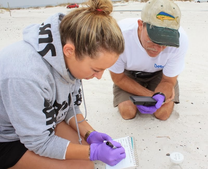 WHOI researcher Catherine Carmichael works alongside high school science teacher Shawn Walker to collect oiled sand patty samples for analysis. Walker's students from West Florida High School of Advanced Technology in Pensacola will conduct field work on Feb. 28 at Pensacola beaches as part of the Gulf Oil Observers (GOO) project led by the Deep-C Consortium. (Photo credit: Danielle Groenen, Deep-C Consortium)
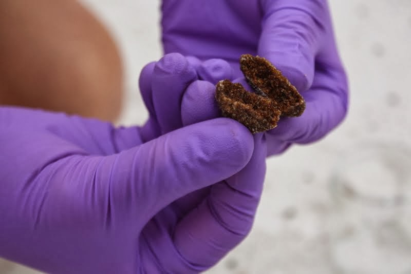
February 25, 2014 -- The BP Deepwater Horizon oil spill may have been nearly four years ago, but scientists are still analyzing the after effects of the disaster that threatened the Gulf Coast. And now, they're bringing in high school students to help.
On February 28, a research team from Florida State University and the Massachusetts-based Woods Hole Oceanographic Institution (WHOI) will be joined by about 25 Pensacola-area high school students from West Florida High School of Advanced Technology to scour a nearby beach in Perdido Key for oil patties that formed as a result of the Deepwater Horizon blowout.
“An activity like this creates excitement for the students,” said Eric Chassignet, director of the Deep-C Consortium and the Center for Ocean-Atmospheric Prediction Studies, which houses the consortium’s efforts at FSU. “It’s real research. They’re out there with actual scientists, collecting samples. And it provides researchers with needed samples from the Gulf of Mexico.”
The Deep-C research project is a long-term study investigating the environmental consequences of oil released in the deep Gulf on living marine resources and ecosystem health.
“I cannot think of better vehicles to engage students than getting their hands dirty and learning how the world, in particular the ocean, works,” said Dr. Christopher Reddy, a WHOI marine chemist and scientist with Deep-C. "Working outdoors on a beach is a great way to get young scientists out of the classroom and into the field where they often develop a strong bond to the work. And when they know they are participating in something more than just another homework assignment, there is considerably more buy-in."
|
|
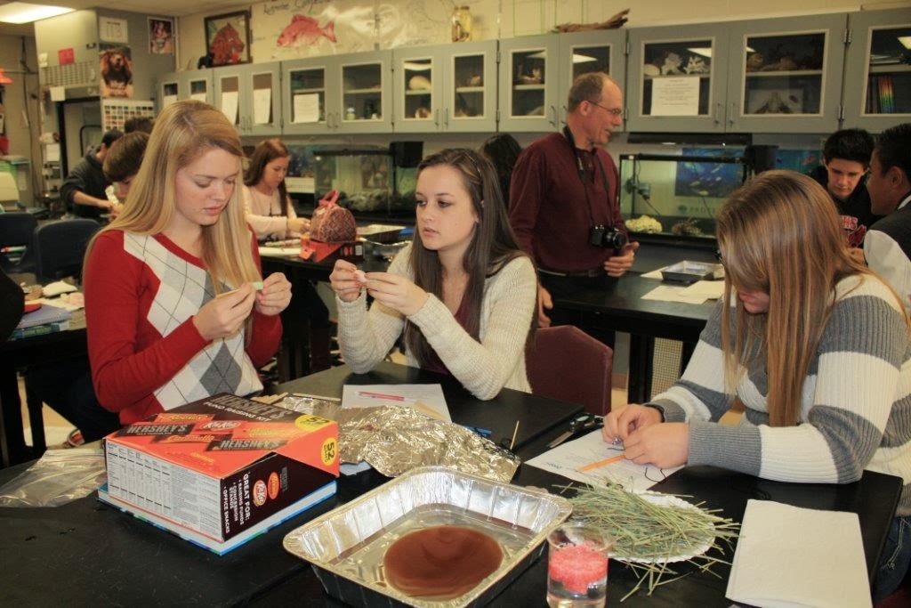 Students designing their methods of cleaning up the oil spill as part of a hands-on activity. (Photo credit: Danielle Groenen, Deep-C Consortium)
In November 2013, Deep-C educators Danielle Groenen and Amelia Vaughan began visiting the West Florida High School of Advanced Technology to work with Shawn Walker, a marine science teacher. The Deep-C mentors brought action-packed lesson plans that engaged and motivated students, which Walker very much appreciated: “Their hands-on lab activities, video presentations, relevant articles, and direct instructional approaches showed significant pre-planning and organizational skills. More important, was their genuine desire to make a positive and lasting impression on the students they are working with.”
Said Chassignet: “We are trying to determine what happens to the oil after it is released. Where does it go? How does it end up as patties along the beach? And how does it affect the local ecology?”
The Deepwater Horizon oil spill is considered the largest accidental oil spill in the history of the oil industry, dumping roughly 4.9 million barrels — or 210 million gallons — of oil into the Gulf of Mexico.
BP, as part of its cleanup efforts, set aside millions of dollars for research. The Deep-C Consortium, which consists of 10 universities and research institutions, received a three-year, $20 million grant from the Gulf of Mexico Research Initiative (GoMRI) to conduct research and educational outreach.
Amelia Vaughan, an education and outreach coordinator with Deep-C Consortium, has been making regular trips to Pensacola to help train students for the upcoming trip.
“It can be hard for students to conceptualize what science or what research is,” Vaughan said. “But with this, they’ll be out in the field seeing what it’s really like.”
Students, alongside their mentors from FSU and Woods Hole, will spend several hours at two sites on the beach collecting these oil patties and placing them in glass sample jars. These samples will then be immediately sent to Woods Hole for analysis. The samples collected during the GOO field study will be sent to WHOI for analysis in order to determine what they are comprised of and if they contain oil from the Deepwater Horizon spill. Through the on-line database, GOO volunteers will be able to track the results of their samples while Deep‐C scientists can use the data to further their research efforts.
"Project GOO is a fantastic opportunity for teachers to provide their students with real world applications of science concepts and skills learned in the classroom.” says Danielle Groenen, Deep-C outreach specialist and designer of the Project GOO curriculum which includes specially designed lesson plans geared toward understanding ocean science and oil spill research.
Read more about GOO:
- GoMRI Article: Oil Patty Research with Top Scientists Turns Students into Citizen Science Enthusiasts
- Woods Hole Oceanographic Institution (WHOI) Press Release: Scientists Train the Next Generation on Oil Spill Research
- Florida State University (FSU) Press Release: Scientists Team Up with High School Students on Oil Spill Research
- GOO Photo Gallery
The Deep-C (Deep Sea to Coast Connectivity in the Eastern Gulf of Mexico) Consortium is a long-term, interdisciplinary study of deep sea to coast connectivity in the northeastern Gulf of Mexico. The study is investigating the environmental consequences of petroleum hydrocarbon release in the deep Gulf on living marine resources and ecosystem health. Deep-C research is made possible by a grant from BP/The Gulf of Mexico Research Initiative. Deep-C Mentors Team with High School Students on Oil Spill Research
ROV Competition Teaches Marine Science and Underwater Technology to Educators and High School Students
Focus on developing Science, Technology, Engineering, and Math (STEM) skills has gained nationwide attention in K-12 education. The purpose is to excite and prepare students for majors and careers as scientists, technologists, engineers and mathematicians in order to meet the growing demands of the 21st century. As part of Deep-C’s commitment to increasing the number of future STEM professionals, the Consortium sponsors an annual teacher workshop and student competition.
|
|
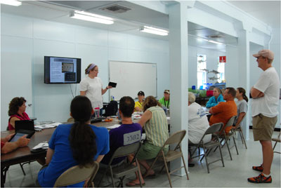 DISL instructor Carrie Dixon-Riley explains in the intricacies of wiring ROV motors to workshop participants. (Photo credit: Tina Miller-Way, DISL)
Aimed at exciting teachers and students about the possibilities of STEM education, the Dauphin Island Sea Lab (DISL) hosts teachers from the Florida panhandle for an annual marine science and underwater technology workshop. Interested high school educators who teach environmental science, marine science, physics, engineering, or physical science can apply to participate in the workshop and competition on the DISL website. Two teachers per school are required, and they must have administrative support for the team component to be eligible for participation.
If selected, the teachers spend four days learning about Remotely Operated Vehicle (ROV) construction and activities that they can implement in the classroom to enhance students understanding of buoyancy, basic engineering principles, basic circuitry and deep sea oceanography. DISL designed the workshop to provide educators with an engaging and fun way to teach marine science and underwater technology in their classrooms. (Read about last summer's teacher training workshop).
The summer workshop is the first in a series of related activities that the teachers and their students participate in over the school year and beyond. They leave the workshop and return to their schools with building supplies and a mission — assemble a team of enthusiastic students who can take on the challenge of building their own ROV for a student competition the following spring.
The Annual ROV Competition
Months of preparation culminate in an ROV competition where student teams test their creations and themselves.
|
|
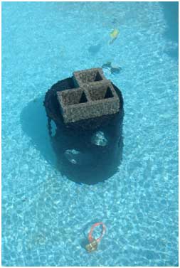
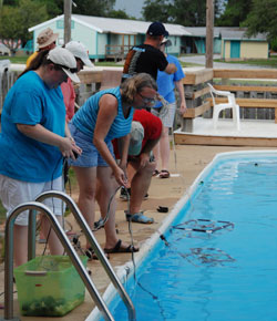
The pool at DISL is transformed into "Mission Control" as each student team completes a series of tasks ranging from successfully navigating through a hoop to identifying several marine species. Competitors participate in two rounds of missions followed by team presentations where they share their design process and what they learned. A panel of judges observes the missions and presentations. Then the judges interview the teams, ask questions about how their ROV was constructed, adjustments or improvements made between missions, and any lessons learned.
The weekend consists of more than just competition, however, as the students and teachers are also able to visit the DISL Estuarium, deploy a professional ROV in the Gulf of Mexico, and learn about how ROVs are used in the field with a presentation by scientitsts who use ROVs in their research. (Read about last summer's competition.)
![]() According to Tina Miller-Way, chair of DISL's Discovery Hall Programs which created and oversees the annual Deep-C ROV competition, students who participate demonstrate increased understanding of circuitry; concepts of hydrodynamics and buoyancy; the use of ROVs in marine research, industry and exploration; possible careers in these fields and an appreciation of effective teamwork. And if that wasn’t enough, students, teachers and the DISL staff have a great time hosting the competition!
According to Tina Miller-Way, chair of DISL's Discovery Hall Programs which created and oversees the annual Deep-C ROV competition, students who participate demonstrate increased understanding of circuitry; concepts of hydrodynamics and buoyancy; the use of ROVs in marine research, industry and exploration; possible careers in these fields and an appreciation of effective teamwork. And if that wasn’t enough, students, teachers and the DISL staff have a great time hosting the competition!
More Information about the ROV workshops and Competition
- See highlights from the 2013 ROV Competition
- See highlights from the 2013 teacher workshop
- See highlights from the 2012 teacher workshop
- Apply to participate in the next ROV teacher workshop
- 2014 ROV Competition Fact Sheet (PDF)
The Deep-C (Deep Sea to Coast Connectivity in the Eastern Gulf of Mexico) Consortium is a long-term, interdisciplinary study of deep sea to coast connectivity in the northeastern Gulf of Mexico. The study is investigating the environmental consequences of petroleum hydrocarbon release in the deep Gulf on living marine resources and ecosystem health. Deep-C research is made possible by a grant from BP/The Gulf of Mexico Research Initiative.
 Tina Miller-Way |
MAKING CONNECTIONS
Stories of students connecting with Deep-C science and scientists
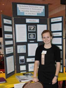
An important outcome of the 2010 Deepwater Horizon oil spill has been its value as a teachable event. It has given rise to new and expanded research into the impacts of oil, dispersed oil, and dispersant on the ecosystems of the Gulf of Mexico. It has also focused attention on the importance and relevance of science, technology, engineering and math (STEM). Students interested in STEM have had the chance to investigate topics that intrigue them – through science projects, volunteer work, and internships. Those students who have reached out to Deep-C scientists have tapped a valuable resource. From answering questions by phone or email, to sometimes even agreeing to host a student in their research environment, many Deep-C scientists devote time to work with middle and high school students – providing them insight into the scientific process and enabling them to develop technical and analytical skills. We look forward to featuring these student/scientist relationships in the coming months in an online series, MAKING CONNECTIONS. The inaugural profile features Elizabeth Smithwick, a high school sophomore whose interest in hydrocarbon degrading bacteria led her to contact Dr. Joel Kostka at the Georgia Institute of Technology.
Self-motivation and perseverance make the most of mentorship
|
|
– Posted April 30, 2013 –
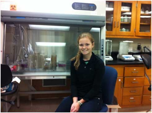
When Elizabeth Smithwick, a sophomore at Episcopal High School in Jacksonville, Florida contacted Dr. Joel Kostka, she was hoping to talk to him as someone who had worked with hydrocarbon degrading bacteria. Elizabeth had an idea for a science project, but realized that she needed guidance and maybe even access to a research lab if she was going to do something really extraordinary.
“I had been working for awhile in a hospital microbiology lab,” Elizabeth explains. “But I wanted to investigate how bacteria degradeor remove oil naturally from the environment. And since the hospital dealt with clinical bacteria, they suggested I discuss my project with someone who specialized in environmental microbiology.”
An Internet search led to her contact Kostka, whose lab at the Georgia Institute of Technology (GaTech) combines cutting edge microbiology and molecular biology with biogeochemistry. Kostka’s work on the role of microbes in helping to clean up oil spills made the mentorship a perfect fit since Elizabeth’s interest was in examining microbes in the St. Johns River that degrade oil.
“Elizabeth had read my paper on hydrocarbon-degrading bacteria in beach sands contaminated with oil from the Deepwater Horizon discharge,” explains Kostka. “So her project was certainly in line with the work we are doing.”
“I was most interested in learning how scientists isolate and identify the bacteria, “Elizabeth said. “I already knew they would use some kind of selective agar, but they showed me how to make it. Also, I was very interested in identifying the bacteria genetically, and was wondering how I could accomplish that.”
|
|
Her initial email to Kostka led to ongoing collaboration and in October 2012, Elizabeth accepted an invitation to visit the Kostka Lab at Georgia Tech. She spent time learning about oil spills and how microbes help to degrade oil in the oceans. She also spent time with Will Overholt and Kala Marks, a Ph.D. student and undergraduate student (respectively) in Kostka’s lab. Students at Georgia Tech are studying how a succession of microbial populations, each adapted to different types of hydrocarbon compounds, are involved in the natural cleanup of oil on Gulf coast beaches. Both Overholt and Marks noted that during her visit, Elizabeth listened very carefully to what they had to teach her.
|
|
Kostka was impresssed by how self-motivated and highly independent Elizabeth is. For example, she insisted on isolating her own microbes that degrade oil, rather than working with bacterial strains that had already been isolated.
“She really persevered!” Kostka recalls. “She asked a lot of questions and kept coming back to us to learn more. Elizabeth demonstrated that self-motivation and commitment are as important to the research process as brute knowledge.”
Working with the St. Johns River Keeper, she collected samples from oil-contaminated sediments of the St. Johns River. Elizabeth then isolated oil-degrading bacteria from the contaminated sediments and sent the Kostka Lab the isolates so they could help her to identify the bacteria.
Her hard work paid off when Elizabeth won first place at the regional science fair, which earned her a place at the state competition, where she placed third. She also placed third in Environmental Sciences at the Science and Engineering Fair of Florida, was awarded a four-year $54,000 scholarship at Florida Institute of Technology, and won the regional U.S. Stockholm Water prize, a contest exclusively for water related projects.
Based on her experience, Elizabeth has some advice for other high school students in her position: “I would tell them, if they see an article that appears interesting to them, try to contact the author. The worst they could do is say 'no' and often times they are very willing to help.”
Elizabeth says she is grateful for her contact at GaTech with Kostka and his team. “I have always been interested in becoming a researcher, and my visit to the Kostka Lab only reinforced that. Everyone was very knowledgeable and willing to work with me. If I do become a researcher, I hope that I can help students pursue research like they helped me,” promises Elizabeth.
|
|
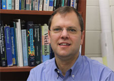 Deep-C researcher Dr. Joel Kostka, Georgia Institute of Technology
Dr. Joel Kostka is a professor of microbial ecology at the Georgia Institute of Technology in Atlanta, GA. His research addresses the role of microbes in how ecosystems function, especially in the areas of water quality and nutrient cycling. Kostka’s involvement in the Deep-C Consortium includes investigating how quickly the Deepwater Horizon oil carried into Gulf of Mexico beach sands is being degraded by the sands' natural microbial communities, and whether native oil-eating bacteria that wash ashore with the crude are helping or hindering that process.
Read more: Science Fair Winners Announced and Episcopal Students Win at Science and Engineering Fair of Florida
The Deep-C consortium is a long-term, interdisciplinary study investigating the environmental consequences of petroleum hydrocarbon release in the deep Gulf of Mexico on living marine resources and ecosystem health. The consortium focuses on the geomorphologic, hydrologic, and biogeochemical settings that influence the distribution and fate of the oil and dispersants released during the Deepwater Horizon accident, and is using the resulting data for model studies that support improved responses to possible future incidents.
Numerical study suggests that subsea injection of oil-dispersing chemical at Macondo well did not prevent oil from rising to the surface
|
|
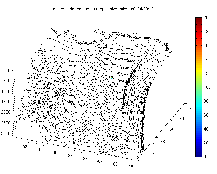
 Screen Capture: June 9, 2010 snapshot of the simulated Deepwater Horizon oil spill -representation of the oil transport reveals the formation of the prominent deep hydrocarbon plume and the layering of shallower plumes. The color-bar represents oil particle depth in meters, where red particles are below 1000 m. Particles reaching the upper 20 m of the water column are shown in magenta (pink) and depict the transport of oil at the surface. The decoupling of the deep and sub-surface oil transport is evident.
By This email address is being protected from spambots. You need JavaScript enabled to view it., University of Miami Rosentiel School of Marine and Atmospheric Science
MIAMI — December 4, 2012 - The 2010 blowout of the Macondo well in the waters of the Gulf of Mexico resulted in the region’s largest oil spill in U.S. history. As the Deepwater Horizon (DWH) incident unfolded, in an effort to prevent the oil from coming to the surface and reaching coastal and marsh ecosystems, chemical dispersants were injected at the wellhead. These powerful dispersants, typically used to break up oil slicks at the sea surface had never been used in such large quantities and over such a prolonged period of time in the deep ocean.
A new study published in Environmental Science & Technology, led by University of Miami (UM) Rosenstiel School of Marine & Atmospheric Science Associate Professor of Applied Marine Physics Claire Paris, is the first to examine the effects of the use of unprecedented quantities of synthetic dispersants on the distribution of an oil mass in the water column, based on a modeling approach. The team of researchers included UM Rosenstiel School Assistant Scientist Matthieu Le Henaff and Research Associate Professor Villy Kourafalou, UM Center for Computational Science (CCS) Scientist Judith Helgers and Research Associate Professor Ashwanth Srinivasan, Ph.D. Candidate Zachary Aman from Colorado School of Mines, Research Associate Professor Ajit Subramaniam from Lamont Doherty Earth Observatory at Columbia University, and Professor Dong-Ping Wang from the School of Marine and Atmospheric Science of SUNY at Stony Brook. Together they developed and tested models to show that the application of oil-dispersing chemicals had little effect on the oil surfacing in the Gulf of Mexico.
“Deepwater drilling into large, high-pressure reservoirs of oil and gas located far offshore and hundreds of meters below the ocean’s surface involves risks for which we were not adequately prepared,” said Paris. “As the oil gushed uncontrolled into the Gulf, injection of chemical dispersant into the deep ocean may have had little effect because the oil was coming out with such pressure that it was already dispersed in small droplets. It is impossible to know whether the synthetic dispersant was well mixed with the oil as it was injected. Our models treat both scenarios, and regardless of whether you have the dispersant in the water mixture or not, the amount of oil reaching the sea surface remained relatively unchanged.”
The researchers estimated the distribution of oil droplet sizes with and without injection of dispersant at the wellhead. They then applied a novel oil-mass tracking model of the Connectivity Modeling System (CMS) developed shortly after the DWH incident with a RAPID award from the National Science Foundation (NSF) and presented a three-dimensional simulation of the DWH spill showing the unfolding of the disaster to examine the effect the synthetic dispersant may have had on the oil transport in the water column. The model indicated that the dispersant injected at BP's Macondo wellhead was not necessary to break up the oil. The subsea application of dispersant did not have its expected outcome.
“This study is notable because it presents a comprehensive estimate of the Macondo blowout from the microscopic oil-water interface through the macroscopic transport of crude oil.” said chemical engineer Aman.
The work served as a milestone in assessing the three dimensional transport of oil in the water column. “Since the beginning of the spill our model accurately predicted the decoupling between the surface and subsea oil transport, and was unique in showing the southwest extension of the deep plume,” said physical oceanographer Le Henaff. “Correct assessment of upwelling and downwelling currents for the circulation model created a realistic scenario that we then used to test the effect of the injection of dispersant on the oil partition.”
As global deep-sea oil exploration expands, the model will be helpful in quantifying the utility of synthetic dispersants for deep water oil leaks. “The CMS oil model was able to predict the strange layering of oxygen deficit anomalies that we observed during our field sampling and provided us a three dimension view of a phenomena that was constantly changing in time. For us, it was like being able to track the ghosts of the oil plume because the oil itself had been consumed by the microbes and all that was left were the oxygen anomalies and the model was critical for us to understand what we were observing in the field,” said biological oceanographer Subramaniam.
These findings expand on a previous study published earlier this year in which the team studied the crucial role of wind-induced surface drift on the fate of the oil in the Gulf of Mexico. “This current study reveals unexplored pathways of the oil transport by underwater currents and highlights the importance of topographic interactions and vertical flows in moving the deep plume toward deep waters or up the water column.” said physical oceanographer Wang.
This study was supported by the NSF-RAPID OCE 1048697 award to C. Paris. The contribution of Paris and Kourafalou were also made possible in part by grants from The Gulf of Mexico Research Initiative, to the Center for Integrated Modeling and analysis of the Gulf Ecosystem (C-IMAGE) and the Deep Sea to Coast Connectivity in the Eastern Gulf of Mexico (DEEP-C), respectively. The Metcalf Institute for Marine & Environmental Reporting at the University of Rhode Island Graduate School of Oceanography was essential in bringing a chemical engineer, Zachary Aman, to the team via the NSF-RAPID DRL-10-55381 to Sunshine Menezes.
The CCS has emerged as a leader in providing a robust cyber infrastructure designed to address major computational challenges, and is now recognized among the State’s top academic centers, and is gaining national prominence for its work. Its high performance computer core supports work a variety of fields such as genomics, computational biology, marine ecosystems modeling, climate and meteorology, computational fluid dynamics and social systems informatics. For more information, please visit www.ccs.miami.edu.
The University of Miami’s mission is to educate and nurture students, to create knowledge, and to provide service to our community and beyond. Committed to excellence and proud of the diversity of our University family, we strive to develop future leaders of our nation and the world. Founded in the 1940’s, the Rosenstiel School of Marine & Atmospheric Science has grown into one of the world’s premier marine and atmospheric research institutions. Offering dynamic interdisciplinary academics, the Rosenstiel School is dedicated to helping communities to better understand the planet, participating in the establishment of environmental policies, and aiding in the improvement of society and quality of life. For more information, please visit www.rsmas.miami.edu.
The Deep-C consortium is a long-term, interdisciplinary study investigating the environmental consequences of petroleum hydrocarbon release in the deep Gulf of Mexico on living marine resources and ecosystem health. The consortium focuses on the geomorphologic, hydrologic, and biogeochemical settings that influence the distribution and fate of the oil and dispersants released during the Deepwater Horizon accident, and is using the resulting data for model studies that support improved responses to possible future incidents.
|
|

Dr. Villy Kourafalou is a member of the Deep-C Consortium's Modeling Task Group. Dr. Kourafalou is a Research Associate Professor at UM’s Rosenstiel School of Marine and Atmospheric Science, where she leads the Coastal and Shelf Seas Group in the Division of Meteorology and Physical Oceanography. She is also the co-Director of the Ocean Modeling and Observing System Simulation Experiments joint center with the Atlantic Oceanographic and Meteorological Laboratory of the National Oceanic and Atmospheric Administration (NOAA). Her research focuses on numerical modeling of circulation and transport on continental shelves and marginal seas, including coastal processes influenced by land runoff, weather events and deep sea oceanic currents.
|
|

Dr. Ashwanth Srinivasan is a member of the Deep-C Consortium's Modeling Task Group. His research interests include Numerical modeling and the application of inverse Methods to Oceanic Problems, High performance computing, scientific code development and parallel computing, Bio‐physical modeling and marine population connectivity studies and Oceanography of the Indian Ocean. Dr. Srinivasan’s Consulting and Support Areas are Earth and Eco‐system modeling and data assimilation, Development, optimization and parallelization of large scientific codes and Operational Ocean and Atmospheric modeling, data management and distribution.
ROV Workshop Teaches Marine Science and Underwater Technology to Educators and High School Students
|
|
July 2012 -- Aimed at exciting high school teachers and students about the possibilities of science, technology, engineering, and math (STEM) education, Dauphin Island Sea Lab (DISL) facilitated Deep-C's first teacher workshop July 22-26, 2012. DISL designed the workshop to provide educators with an engaging and fun way to teach marine science and underwater technology in their classrooms. It was the first in a series of related activities that the selected teachers and their students will participate in over the next two years as part of Deep-C’s commitment to increasing the number of future STEM professionals.
Focus on developing STEM skills has gained nationwide attention in K-12 education. The purpose is to excite and prepare students for majors and careers as scientists, technologists, engineers and mathematicians in order to meet the growing demands of the 21st century.
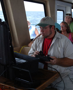
 Workshop participants test their ROVs. (Photo credit: Tina Miller-Way, DISL) |
“Enthusiastic and well-prepared educators are the key to a successful STEM effort,” says Tina-Miller-Way, Chair, DISL Discovery Hall Programs. “Our program is designed to inspire teachers and students to explore science in a way that goes beyond textbooks by giving them hands-on science and technology experiences.”
The 12 teachers selected to participate in this inaugural workshop came from around Florida. The subjects taught by participants include biology, physics, math, robotics and chemistry.
During the course of the four-day workshop, participants built a remotely-operated vehicle (ROV) from simple motors, basic wiring and PVC pipe and tested their design in a pool. The teachers also attended lectures and had discussions with scientists, such as Deep-C researcher Dr. Amy Baco-Taylor (Florida State University), who use ROVs in their research. An overview of the Deep-C project was presented by Dr. Felicia Coleman, Deep-C’s scientific director and director of the Florida State University Coastal and Marine Laboratory.
|
|
There were numerous hands-on activities including classroom activities exploring buoyancy, basic engineering principles, basic circuitry and deep sea oceanography. They also discussed how ROV technology can be integrated into high school curricula that are tied to state and national standards. Perhaps most fun of all was an all-day boat trip where the participants deployed and piloted a research ROV around the hard bottom habitats offshore of Mobile Bay. They also had the opportunity to use common sampling equipment such as CTDs, trawls, grabs and plankton nets while on the boat. On the last day, teachers conducted a mock competition with their uniquely designed ROVs as this multi-phase program will culminate in a remotely-operated vehicle (ROV) regional competition for their students in the spring of 2013 and 2014.
“The nature of the Deep-C project — the issues involved in understanding and protecting ecological communities in the Gulf of Mexico — provides rich opportunities for engagement with K-12 teachers and students,” says Tracy Ippolito, Deep-C Coordinator. “Through the work Deep-C is doing, we can help promote science education in tangible ways, and share some of the wonder and awe of scientific discovery.”
The Deep-C (Deep Sea to Coast Connectivity in the Eastern Gulf of Mexico) Consortium is a long-term, interdisciplinary study of deep sea to coast connectivity in the northeastern Gulf of Mexico. The study is investigating the environmental consequences of petroleum hydrocarbon release in the deep Gulf on living marine resources and ecosystem health. Deep-C research is made possible by a grant from BP/The Gulf of Mexico Research Initiative.
Tina Miller-Way |
Studies of DeSoto Canyon and Shelf Demonstrate Upwelling During Hurricane Isaac
Deep-C Consortium Scientists Survey Ocean to Better Understand Movement of Tar Balls in Gulf Mexico
|
|
 UM team during a pre-flight briefing with NOAA’s flight crew at MacDill Air Force Base. Photo credit: Jodi Brewster.
As Hurricane Isaac barreled toward New Orleans, a team led by University of Miami (UM) Professor and Deep-C (Deep Sea to Coast Connectivity in the Eastern Gulf of Mexico) Co-Principal Investigator Nick Shay was planning NOAA’s P-3 aircraft missions to fly into the storm. Dr. Benjamin Jaimes and UM senior research associate Jodi Brewster and graduate student Ryan Schuster prepared and loaded 39 profilers into the plane. Their goal: to drop these profilers into the storm at optimum locations where they could collect measurements of ocean heat content, salinity and currents during the hurricane.
“We wanted to collect data from the DeSoto Canyon area where the Deepwater Horizon incident occurred, so we could capture the upwelling as it was occurring,” said Shay, who is an expert on the Loop Current and regularly studies weather in this region. “We used operational products that we developed for NOAA’s National Environmental Satellite Data and Information Service (NESDIS) to study the warm and cold core eddy ahead of the storm to establish drop points and deploy three different types of devices that penetrate to depths of 4,500 feet.”
The experiment was planned as a component of NOAA's 2012 Hurricane Field Program, coordinated by the Hurricane Research Division at the Atlantic Oceanographic and Meteorological Laboratory. Prior to Hurricane Isaac the team flew over the area and deployed 54 devices to collect baseline oceanic and atmospheric data over the shelf and shelf break. After the storm, the team worked with the flight crew at NOAA’s Aircraft Operation Center located at MacDill Air Force Base to deploy another 67 probes and get a post-hurricane snapshot of the area tying the response from several research flights. The information from each of the flights is being analyzed by scientists, and for input into both research models that are being developed for Deep-C as well as operational models at forecasting centers.
 UM graduate student Ryan Schuster prepares and loads profilers into the plane. |
“From previous hurricanes like Ivan and Frederic we knew this area was prone to upwelling, and deep sea responses to the events taking place in the atmosphere. These areas have high humidity and strong surface wind activity which may lead to tar balls washing ashore – which may have the same chemical fingerprint as the oil spill. We are interested in this possibility, and the long term impacts it might have on the coastal ecosystem,” said Shay.”
Hurricane Isaac presents a unique opportunity to investigate that possibility. Since the Deepwater Horizon accident, Deep-C scientists have visited and revisited sites along the Gulf Coast that were affected by the oil spill. A team scoured the beaches as recently as one week before Hurricane Isaac, looking for samples of oil that have mixed with sand to create what are referred to as "sand patties." Immediately following the storm, those Deep-C teams led by Deep-C investigators Dr. Chris Reddy of the Woods Hole Oceanographic Institution (WHOI) and Dr. Wade Jeffrey of the University of West Florida, returned to the beaches and collected additional samples.
|
|

“Our intent,” Reddy said, “is to determine if these post-storm samples contain oil from the Deepwater Horizon spill and, if so, if they are in fact a result of the upwelling and deep sea responses to the recent hurricane.” One of the ways the fate of the oil can be determined is to study an effect called weathering — that is, how oil that is discharged into the environment changes over time. Weathering affects the properties of spilled oil and according to Reddy, oil from the deep bottom is likely to have weathered differently than samples already on the shore prior to the storm that were simply unearthed or exposed by the winds and rain of Hurricane Isaac.
“We are doing a careful and prudent analysis of the samples found to determine if they are, in fact, Deepwater Horizon oil from the deep sea,” Reddy said.
The Deep-C consortium is a long-term, interdisciplinary study investigating the environmental consequences of petroleum hydrocarbon release in the deep Gulf of Mexico on living marine resources and ecosystem health. The consortium focuses on the geomorphologic, hydrologic, and biogeochemical settings that influence the distribution and fate of the oil and dispersants released during the Deepwater Horizon accident, and is using the resulting data for model studies that support improved responses to possible future incidents.
The University of Miami Rosenstiel School of Marine & Atmospheric Science, Woods Hole Oceanographic Institution, and the University of West Florida are all Deep-C member institutions.
|
|

The University of Miami’s mission is to educate and nurture students, to create knowledge, and to provide service to our community and beyond. Committed to excellence and proud of the diversity of our University family, we strive to develop future leaders of our nation and the world. Founded in the 1940s, the Rosenstiel School of Marine & Atmospheric Science has grown into one of the world’s premier marine and atmospheric research institutions. Offering dynamic interdisciplinary academics, the Rosenstiel School is dedicated to helping communities to better understand the planet, participating in the establishment of environmental policies, and aiding in the improvement of society and quality of life. Dr. Lynn "Nick" Shay’s research interests include: upper ocean response and coupled atmosphere-ocean interactions, coastal ocean circulation processes, surface wave current interactions and atmospheric and oceanic boundary layer interactions.
|
|

Dr. Chris Reddy is a senior scientist in the Woods Hole Oceanographic Institution's Department of marine chemistry and geochemistry. Since April 2010, he has devoted most of his research efforts to studying the Deepwater Horizon oil spill in the Gulf. He has studied numerous other oil spills including oil leaking from a Japanese warship sunk in 1945. WHOI is a private, independent, non-profit organization in Falmouth, Mass., dedicated to marine research, engineering, and higher education. Established in 1930 on a recommendation from the National Academy of Sciences, its primary mission is to understand the ocean and its interaction with the Earth as a whole, and to communicate a basic understanding of the ocean's role in the changing global environment.
|
|

Dr. Wade Jeffrey is a professor of biology at the University of West Florida (UWF) where faculty, staff, and students are active in marine ecology, fisheries, economics, tourism and oil bioremediation. UWF has been on the forefront of the response to the DwH spill since the first few weeks, and brings considerable skills and knowledge gained from this experience. The Center for Environmental Diagnostics and Bioremediation (CEDB) is a small environmental research group focusing on microbial processes and biogeochemistry in the open ocean, estuaries, and watersheds, including bioremediation and pollution studies, working with academic departmental faculty in Biology, Chemistry and Environmental Studies.
October Science Café: Marine Life after the BP Oil Spill
October 2012 Science CaféWhen: Oct. 2, 6:15 to 7:30 p.m.
|
TALLAHASSEE, Fla. — Dean Grubbs has been up close with 15-foot tiger sharks — all in the name of science, of course. A marine ecologist and fish expert, his latest project is to study the effects of the 2010 BP Deepwater Horizon oil explosion — which spewed about 210 million gallons of crude into the Gulf of Mexico — on the creatures that live in the deep waters closest to the disaster.
|

The oil explosion killed 11 people, injured 17 others and is reportedly the largest accidental marine oil spill in the history of the petroleum industry.
Grubbs, an associate scholar scientist at the Florida State University Coastal and Marine Laboratory in St. Teresa, will talk about what he and others have discovered at the next MagLab-sponsored Science Café on Oct. 2. The discussion begins at 6:15 p.m. and wraps up at 7:30 p.m. at Ray’s Steel City Saloon, 515 John Knox Road, just across the street from the Tallahassee Mall. Arrive early for a good seat.
“I hope people will come away from my talk realizing that we have this unique ecosystem full of all these crazy, wonderful deep-water species that no one really knows much about,” Grubbs said. “We know less about them than we do about the moon.”
For the last one and a half years, Grubbs has been studying tilefish and hake fish, cutthroat eels, dogfish (a type of small shark), sixgill sharks and gulper sharks. His work is part of the FSU-led Deep-C Consortium, a long-term, interdisciplinary study of the northeastern Gulf of Mexico made possible by a grant from the BP/The Gulf of Mexico Research Initiative. Grubbs and his colleagues are investigating a part of the Gulf called the DeSoto Canyon, a deep, underwater valley off the coast of Pensacola. They want to know what kind of animals live in and around this area at depths that range from 0.1 mile to slightly more than a mile below the surface (200 to 2,000 meters).
They’re also investigating how oil-related toxins, such as polycyclic aromatic hydrocarbons (or PAHs), may be affecting them.
|

“What we can say at this point is, yes, the closer you get to the oil spill, the more fish are metabolizing the PAHs, but what we are seeing so far is that it’s at a pretty low level,” Grubbs said.
Grubbs and others have caught and examined about 1,500 fish (spanning 52 species) for their ongoing project. Some fish have higher levels of PAHs than others, for reasons that are still unclear. Grubbs and his crew have also found what they think is a new species of skate measuring about 3 feet across.
“That was pretty exciting — and we caught it really close to the Deepwater Horizon site.”
The animals able to live in the cold, dark, deepest waters grow more slowly, Grubbs said.
“The deeper you go, the fewer animals you see that can live down there. The deeper you go, the slower the animal’s metabolism.”
Some deep-water sharks take up to 25 years to fully mature, he added, and some carry their young for two to three years before finally giving birth. To learn more about them, Grubbs catches and tags the fins of big, deep-water sharks with an electronic transmitter, then releases them back into the ocean. The transmitter sends information about the shark back to Grubbs until it pops off.
Learn more about what’s happening to these incredible animals in the Gulf’s deep waters, and the methods Grubbs and others use to study them, at the Oct. 2 café.
Source: National High Magnetic Field Laboratory
|

Dr. Dean Grubbs, a scientist at The Florida State University Coastal and Marine Laboratory, is studying the fishes from the continental shelf to the deep sea to determine how they were affected by the Deepwater Horizon oil spill. As part of a $20 million research effort led by the Florida State University -- the Deep-C Consortium -- he is concentrating on defining the predator-prey interactions of the fishes found in benthic communities throughout the Panhandle Bight and northern part of the West Florida Shelf.
The Deep-C consortium is a long-term, interdisciplinary study investigating the environmental consequences of petroleum hydrocarbon release in the deep Gulf of Mexico on living marine resources and ecosystem health. The consortium focuses on the geomorphologic, hydrologic, and biogeochemical settings that influence the distribution and fate of the oil and dispersants released during the Deepwater Horizon accident, and is using the resulting data for model studies that support improved responses to possible future incidents.
Speeding back to the Deepwater Horizon: Investigating new sheens of oil two years after the Macondo well was capped
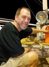
By Dr. Chris Reddy, Woods Hole Oceeanographic Institution
 Chris Reddy |
October 21, 2012 -- Science often moves slowly. But not this time.
Sheens of oil had been spotted on the Gulf of Mexico near the site of the Deepwater Horizon disaster, more than two years after the deep-sea Macondo well had released 160 million gallons of crude oil. I had heard rumors about sheens for months, but I had discounted them as likely resulting from one of many natural oil seeps scattered across the seafloor of the Gulf. BP had “shut in” the well and had inspected it with a remotely operated underwater vehicle with no signs of leaking.
But this time, oil from the sheens appeared to be from Macondo.
|
|
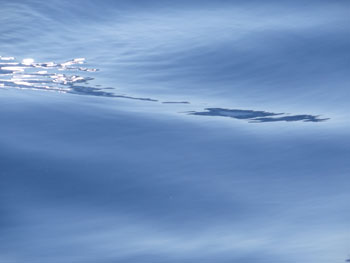 Sheen around the Deepwater Horizon disaster on October 20, 2012. Notice that the oil has “dampened” the sea surface, smoothing its surface expression. We looked for these dampened areas rather than the actually sheens as sunlight made the sheens difficult to see at boat level. (Photo credit: C. Reddy, WHOI)
My colleague, Ian MacDonald at Florida State University (a member of two consortia -- Deep-C and ECOGIG -- studying the impact of the oil spill on the Gulf of Mexico and an expert on natural oil seeps) had called me to tell he thought that some newly observed sheens were likely from the Macondo well. That was Wednesday, October 10, and I was standing in a supermarket on the island of Kauai. Some of my contacts in the federal government, as well as emerging news stories, confirmed his suspicions.
BP reported that the oil sheens contained “drilling mud” and the oil was likely from the riser pipe that had once been tethered between the Deepwater Horizon platform to the Macondo well. Drilling mud is not ordinary mud, but rather a term describing a mixture of hydrocarbons and heavy minerals used during drilling operations. It also has powerful forensic value, as it is not present in the oil reservoir itself.
Finding drilling mud in the sheen suggested that the sheens originated from the drilling operations or operations to stop the leak — not from the Macondo reservoir itself. The new sheens likely came from wreckage at the seafloor, which could contain only small amounts of oil. This was relatively good news.
But researchers at the Marine Safety Laboratory at the United States Coast Guard argued that new samples of oil from the sheen did not contain drilling mud. With this discrepancy, my interest was piqued.
I happen to hold a patent for a highly sensitive and accurate method to analyze drilling mud in oil, and I wanted to determine conclusively if the reported sheens did in fact contain drilling mud. Back in my lab at the Woods Hole Oceanographic Institution in Massachusetts on October 13, I began planning to return to the Deepwater Horizon site.
I had a problem. How would I get there?
I had asked my contacts in the Coast Guard and the National Oceanic and Atmospheric Administration, but these agencies were not currently collecting samples. A BP vessel was on site, but logistical problems prevented me from getting to it. My colleague Ian MacDonald had the only planned academic research expedition to the area, but it was not scheduled until November.
I started looking for fishing boats that make one-day offshore trips. Of course, I would have to pay for the ride, and the boats I found were docked at least 100 miles away from the site. Had we hired these boats to get back and forth to the site, it would leave only an hour to collect samples. My colleague Dave Valentine at the University of California Santa Barbara, who planned to join me, wasn’t any luckier in finding a boat.
On Tuesday night, October 16, I was talking about the spill to a friend of a friend who lives in New Orleans and lamenting to him about my boat problem. He said he could get a ride for me — for free and in a boat that could go at least 60 miles an hour. Wow!
|
|
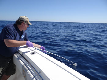 Bob Nelson (Woods Hole Oceanographic Institution) collecting
 The next day, my lab assistant Bob Nelson and I had bought tickets to arrive on Friday. Valentine sent one of his postdoctoral scientists, Mattias Kellermann on Thursday to supply advance ground support.
Valentine rendezvoused with us at 3 p.m. Friday, but by then, the story on the sheens had changed. The well was not leaking. BP had confirmed with underwater video taken by a deep-sea robot, and the Coast Guard agreed, that a cofferdam (a piece of containment equipment that had been used in May 2010 to cover the gushing well) was leaking a small amount of oil. This device, which was the size of a small two-story building, had clogged, leaving a pool of oil trapped inside. Apparently, the device had just been discarded, oil and all, and was now leaking.
Already in New Orleans, Valentine and I tweaked our scientific plans. The containment efforts left us with an excellent experiment: While this oil was trapped at the cold ocean floor, did marine microbes decompose it? Valentine had come equipped to sample bacteria, so we decided to see if we could find chemical and microbiological evidence in the surface slicks of microbial degradation under deep-sea conditions.
At the crack of dawn on Saturday, we drove to the port of Venice on the Mississippi River and met up with our new research vessel. All of us had had experience doing coastal and offshore research, but this boat was quite a surprise. It was an unnamed 36-foot rocket with three 300-horsepower outboard motors and was open to the elements except for a windshield for the captain. Until then, I had thought my new friend’s claim of 60 mph was an exaggeration.
By 9 a.m., we had reached the last stretches of the Mississippi River before entering the Gulf of Mexico. The captain wasted no time in getting us to our research site near the Deepwater Horizon site. Usually that would take 12 hours at 10 miles per hour for a vessel from the academic fleet. Using a handheld GPS, we had calculated that within a few minutes on the river, we were moving more than 60 mph. It was a new experience.
|
|
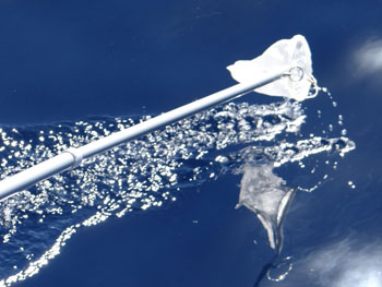 Telescoping pool with Teflon screen being passed through the sea surface. Note the dampened sea surface in the bottom right. (Photo credit: C. Reddy, WHOI)
We slowed down a bit once we reached the ocean, only 40 miles hour, and reached our first research site one kilometer north of the Macondo Well. After two hours, it was a relief to slow down.
Unfortunately, we first could not find any sheen. The seas were a bit choppy and the sun was too high in the sky. Moving in a circle around the location, we finally found (and smelled) the sheens. Compared to what I saw in June 2012 when the oil was stilling flowing and thick slicks of oil were floating, this oil was a light coating of oil. Hence, why we called them sheens.
With sheens to sample, we moved fast, not wanting to push the generosity of our free ride. Using a telescoping pool rod, Nelson passed a super-clean piece of Teflon netting through the sheens, as if he were removing leaves from a pool. Valentine and I had our hands full documenting the research and labeling our sample containers. Kellermann was responsible for tracking our sampling coordinates and working with the boat captain.
Hours later, we had collected eight samples and were headed home. Worn out from the ride to the site and the fieldwork, I dreaded the ride home. Two hours at 40 or more mph is taxing. Bang, slam — your body rattles every time you hit a big wave. But we got to port, exhilarated from getting samples so fast.
We have lots of work to do with those samples and will be sharing them with our Deep-C colleagues Ryan Rodgers and Alan Marshall at Florida State. But the analyses will take a little bit longer than it did to plan and execute this expedition.
Dr. Chris Reddy is a senior scientist in the Woods Hole Oceanographic Institution's (WHOI) Department of marine chemistry and geochemistry. Since April 2010, he has devoted most of his research efforts to studying the Deepwater Horizon oil spill in the Gulf. He has studied numerous other oil spills including oil leaking from a Japanese warship sunk in 1945. WHOI is a private, independent, non-profit organization in Falmouth, Mass., dedicated to marine research, engineering, and higher education. Established in 1930 on a recommendation from the National Academy of Sciences, its primary mission is to understand the ocean and its interaction with the Earth as a whole, and to communicate a basic understanding of the ocean's role in the changing global environment.
Dr. Ian MacDonald is a professor at the Florida State University (FSU). He is an oceanographer of deep-ocean extreme communities. The physical settings include natural hydrocarbon seeps, gas hydrates, and mud volcano systems. Research conducted at FSU first provided realistic numbers of spilled oil, correcting estimates published by BP. FSU has also lead investigations on the influence of oil buried in Florida beaches on microbial community composition and the fate of embedded tar mats. Focus areas extend from marine ecology, fisheries, ocean modeling, winds, remote sensing and meteorology to economics, tourism and risk assessment and remediation.
The Deep-C (Deep Sea to Coast Connectivity in the Eastern Gulf of Mexico) Consortium is a long-term, interdisciplinary study of deep sea to coast connectivity in the northeastern Gulf of Mexico. The study is investigating the environmental consequences of petroleum hydrocarbon release in the deep Gulf on living marine resources and ecosystem health. Deep-C research is made possible by a grant from BP/The Gulf of Mexico Research Initiative.
ECOGIG (Ecosystem Impacts of Oil and Gas Inputs to the Gulf) Consortium brings together physical oceanographers, marine biologists, and chemists from 14 research institutions in a holistic effort to understand the impacts of natural seepage versus that of abrupt, large hydrocarbon inputs on coupled benthic-pelagic processes in deepwater ecosystems in the Gulf of Mexico, and to chart the long-term effects and mechanisms of ecosystem recovery from the Macondo Blowout.
Asphalt in the Seep Ecosystem
Discovering the nature of asphalt deposits in the Gulf of Mexico
By Dr. Ian MacDonald, Florida State University
 Deep-C Scientist Dr. Ian MacDonald |
|
|
October 27, 2012 -- Natural hydrocarbon seeps are a common feature of the Gulf of Mexico. At most seeps, liquid oil and gas escape from reservoirs kilometers below the seafloor, migrate up through faults created by the movement of salt domes, and bubble into the water. Bacteria are able to utilize the oil and gas as a source of nutritive carbon, while dense ecosystems of invertebrates including tube worms and mussels are in turn supported by the bacteria. The break-down of oil and gas at seeps results in layers of carbonate rock, which gradually accumulate as the bacteria produce excess CO2. At other seeps, discharge of oil and gas is associated with dense brines, many times saltier than seawater, that forms from dissolving salt domes and forms pools and rivers on the seafloor. In systems that are highly pressurized and relatively open, oil, gas, brine and mud can erupt in so-called mud volcanoes. So, seeps comprise complex geological, chemical, and biological systems in the deep sea.
In 2003, while exploring the oil seeps in the southern Gulf of Mexico with collaborators from the German research group MARUM, I discovered a different style of seep (MacDonald, Bohrmann et al. 2004). We were exploring a mound in water depths of about 3400 m using a lowered camera platform with a live video feed. After several fruitless hours of watching a relatively featureless ocean bottom pass under the camera, we were shocked out of our chairs when a huge black mass of lava-like material suddenly appeared on the video screen and remained in view for over a minute as the camera platform continued to track along the bottom. It was unlike anything any of us had seen, but around the edges were tube worms and bivalve shells familiar from Gulf of Mexico seeps. We would eventually determine that the black material was asphalt, similar to the tar-like material familiar from the the La Brea tar pit, but never before seen in the deep sea. We named the process asphalt volcanism and it would subsequently be observed offshore California and in the northern Gulf of Mexico as well. Unlike previously known oil and gas seeps, asphalt volcanoes directly create massive substrate — they literally pave the seabed.
|
|
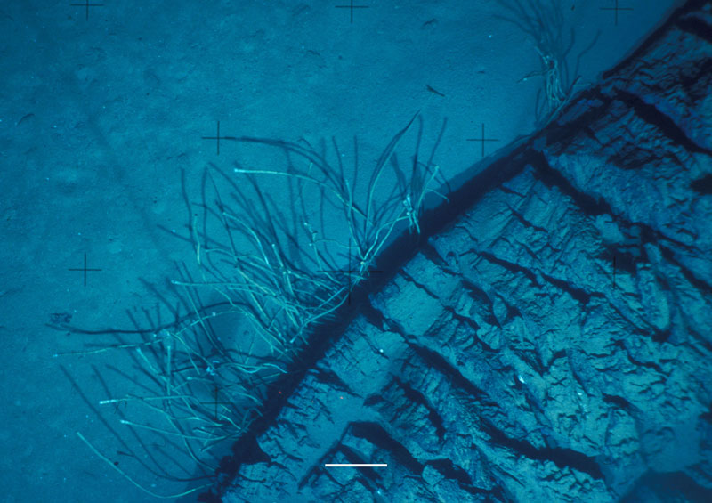
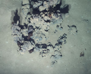 Asphalt extrustion discovered at 2,200 meters during a survey of opportunity made to ground-truth bubble plumes observed by NOAA Ocean Exploration.
 |
|
During the recent Deep-C cruise on the RV Weatherbird (read the Cruise Blog), I had a moment of déjà vu. Once again our team was using a deep sea camera platform to explore a mound deep below the surface. On this occasion, we were working at about 2200 m depth on a small mound we named Peanut. Previous work by the Ocean Exploration team in 2011 had identified bubble plumes rising from this site. Although it was not in our original plan, I had decided to take advantage of a few hours of spare time in our busy sampling schedule and explore the bubble plumes that the OE team had identified. This time, we had success almost immediately — which was fortunate because we really only had a couple of hours to spare. The video camera on the FSU/FIO MILET system (modular instrument lander and equipment toolsled) started picking up shells and bacterial mats almost as soon as we got to the bottom. Less than thirty minutes into the survey I spotted the unmistakable shape of a meter-wide asphalt extrusion. This time the image quality was much improved and we had real-time high resolution digital photographs to accompany the video. It was plain that the asphalt was still fairly fresh in several places.
This discovery is the first time asphalt volcanism has been seen in the eastern Gulf of Mexico. Hydrocarbon reservoirs containing asphalt generally represent material of greater geologic age than oil and gas reservoirs. The finding at Peanut Hill is significant because it probably means that hydrocarbons of very different ages present in the eastern Gulf, which is generally thought to contain more recent reservoirs. Asphalt can be a major problem for drillers because it plays havoc with drill bits and tends to flow back into the hole when drill strings are removed to change drill bits. Ecologically, asphalt hosts sessile invertebrates like seafans and sea urchins. Finding asphalt where it was unexpected is a reminder of how little we know about the deep ocean and that every expedition will learn new things.
Dr. Ian MacDonald is a professor at the Florida State University (FSU). He is an oceanographer of deep-ocean extreme communities. The physical settings include natural hydrocarbon seeps, gas hydrates, and mud volcano systems. In his project work, he uses satellite remote sensing to locate natural oil releases on the ocean surface. Specialty cameras provide high resolution and time-series imaging of seep fauna and processes at the ocean floor. GIS techniques are used for assessing biological communities and geologic features with submersibles and towed cameras.
MacDonald, I. R., G. Bohrmann , et al. (2004). "Asphalt volcanism and chemosynthetic life, Campeche Knolls, Gulf of Mexico." Science 304: 999-1002.
The Deep-C consortium is a long-term, interdisciplinary study investigating the environmental consequences of petroleum hydrocarbon release in the deep Gulf of Mexico on living marine resources and ecosystem health. The consortium focuses on the geomorphologic, hydrologic, and biogeochemical settings that influence the distribution and fate of the oil and dispersants released during the Deepwater Horizon accident, and is using the resulting data for model studies that support improved responses to possible future incidents.
New Research Illustrates Mississippi River’s Role in Transport of Oil and Pollutants in Gulf of Mexico
Study establishes first-ever connections between the Mississippi River plume and transport of oil released by the 2010 Deepwater Horizon oil spill
|
Example of model simulation of strong influence of Mississippi fronts (left, black line) on the observed Surface Oil Patch (SOP, right). Incident when the Mississippi waters (blue and purple colors) entrained oil toward the coasts west of the Mississippi Delta. The Macondo well location is marked with an X.
|

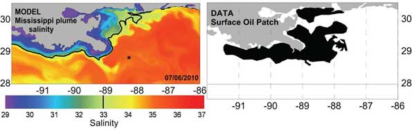
MIAMI (October 23, 2013) – A new study led by scientists at the University of Miami (UM) Rosenstiel School of Marine and Atmospheric Science showed that the complex circulation from the Mississippi River plume played a substantial role in the transport and fate of the oil following the 2010 Deepwater Horizon incident. These findings provide new information on the transport of oil and other pollutants in the Gulf of Mexico. UM Research Associate Professor Villy Kourafalou developed a high-resolution model to examine the movement of the surface oil patch resulting from the deep oil release from the Deepwater Horizon under the influence of daily variability of the Mississippi River. The study employed NOAA observations for the evolution of the surface oil patch and revealed that fronts created by the Mississippi plume helped to keep oil released during the Deepwater Horizon incident away from the coasts east of the Mississippi Delta, while plume currents captured some oil to the west of the Mississippi Delta.
“Since the Gulf of Mexico is such a complex ocean system, and the oil spill was near the Mississippi Delta, we realized we had to carefully account for both the offshore currents and the coastal currents, which are largely dominated by the Mississippi River plume,” said Kourafalou. “The model was validated with data and is now part of an Earth System modeling framework to help inform decision makers in the future.”
During the response to the Deepwater Horizon incident, emergency managers wondered if flooding the Mississippi River might help to divert the oil being released into the water from impacting communities on the Gulf’s north coast. However, no operational computer models with details in river plume dynamics existed that might help predict how the environment might react to being flooded.
This study marks the first time a connection is established between the near surface signatures of a large river plume and the hydrocarbons released from a deep oil plume. The new prediction modeling system can help better understand the transport of oil and other pollutants under the complex circulation in the Gulf of Mexico. Waters of Mississippi origin can be often traced as far south as the Florida Straits, potentially impacting the Florida Keys.
The research, published in the Oct. 2013 issue of the Journal of Geophysical Research: Oceans, was funded by grants from the Gulf of Mexico Research Initiative and the National Science Foundation.
|
|
Dr. Villy Kourafalou is a member of the Deep-C (Deep Sea to Coast Connectivity in the Eastern Gulf of Mexico) Consortium, which is investigating the environmental consequences of petroleum hydrocarbon release in the deep Gulf on living marine resources and ecosystem health. Deep-C is examining the geomorphologic, hydrologic, and biogeochemical settings that influence the distribution and fate of the oil and dispersants released during the Deepwater Horizon (DwH) accident, and using the resulting data for model studies that support improved responses to possible future incidents.
The University of Miami is the largest private research institution in the southeastern United States. The University’s mission is to provide quality education, attract and retain outstanding students, support the faculty and their research, and build an endowment for University initiatives. Founded in the 1940’s, the Rosenstiel School of Marine & Atmospheric Science has grown into one of the world’s premier marine and atmospheric research institutions. Offering dynamic interdisciplinary academics, the Rosenstiel School is dedicated to helping communities to better understand the planet, participating in the establishment of environmental policies, and aiding in the improvement of society and quality of life.
The Gulf of Mexico Research Initiative is an independent body established by BP to administer the company's 10-year, $500 million commitment to independent research into the effects of the Deepwater Horizon incident. Through a series of competitive grant programs, the GRI is investigating the impacts of the oil, dispersed oil, and dispersant on the ecosystems of the Gulf of Mexico and the affected coastal States in a broad context of improving fundamental understanding of the dynamics of such events and their environmental stresses and public health implications.
The Deep-C Consortium is a long-term, interdisciplinary study investigating the environmental consequences of petroleum hydrocarbon release in the deep Gulf of Mexico on living marine resources and ecosystem health. The consortium focuses on the geomorphologic, hydrologic, and biogeochemical settings that influence the distribution and fate of the oil and dispersants released during the Deepwater Horizon accident, and is using the resulting data for model studies that support improved responses to possible future incidents.
Deep-C was a four-year, interdisciplinary study of deep sea to coast connectivity in the northeastern Gulf of Mexico.Deep-C is no longer an active research project. The information on this website is for historical reference purposes only.
Home | About Us | Research Areas | Data Center | News & Multimedia | Education & Outreach
© Deep-C Consortium. All Rights Reserved.
This research was made possible by a grant fromThe Gulf of Mexico Research Initiative (GoMRI).
Copyright | Disclaimer | Privacy Policy