 |
 |
RESEARCHERS
 |
Eric Chassignet (Lead) Florida State University |
 |
Mark Bourassa Florida State University |
| Sergia deRada Naval Research Lab |
|
 |
Dmitry Dukhovskoy Florida State University |
 |
Hannah Hiester Florida State University |
| Lars Hole Norwegian Meteorological Institute |
|
| Pat Hogan Naval Research Lab |
|
 |
Mohamed Iskandarani UM Rosentiel School of Marine and Atmospheric Science |
 |
Villy Kourafalou UM Rosentiel School of Marine and Atmospheric Science |
 |
Steve Morey Florida State University |
| Ashwanth Srinivasan UM Rosentiel School of Marine and Atmospheric Science |
|
 |
Wilton Sturges Florida State University |
 |
Panagiotis Velissariou Florida State University |
 |
Robert Weisberg University of South Florida |
| Cecelie Wettre Norwegian Meteorological Institute |
The Earth System Model
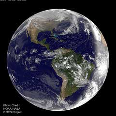
Prediction of the fate of oils, such as those released during the Deepwater Horizon (DwH) oil spill, and their impact (both local and distant) on the environment not only requires detailed knowledge of the Gulf of Mexico 3D circulation (basin-wide and shelf/coastal processes), but also knowledge of the surface winds, waves, sediments, and biogeochemistry. The ocean, atmosphere, land, and biosphere are interconnected in fundamental ways that ensure changes in one realm will reverberate throughout all others.
So there is a need to develop a comprehensive model with the capability to forecast the pathways along which such exchanges occur and predict the level of risk associated with specific outcomes. The Deep-C Consortium is developing this kind of model through the expertise of two teams of experts — the first team focusing on the provision of historical and newly acquired field data in the northeastern Gulf of Mexico to the second team, whose focus is on the Earth System Model prediction system development and validation.
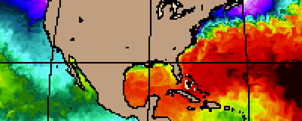
Coupled ocean-atmosphere-wave component – At the heart of the Earth System Model is the coupled ocean-atmosphere-wave component. This component consists of the U.S. Navy's Coupled Ocean–Atmosphere Mesoscale Prediction System (COAMPS) configured for the Gulf of Mexico by the Naval Research Laboratory at the Stennis Space Center. The atmospheric portion of COAMPS consists of a complete three-dimensional data assimilation system that includes data quality control, analysis, initialization, and forecast model components. The nonhydrostatic atmospheric model includes predictive equations for the momentum, the non-dimensional pressure perturbation, the potential temperature, the turbulent kinetic energy, and the mixing ratios of water vapor, clouds, rain, ice, grauple, and snow, and contains advanced parameterizations for boundary layer processes, precipitation, and radiation. Deep-C uses the HYbrid Coordinate Ocean Model (HYCOM) as the ocean component. This model was developed through the HYCOM consortium of academic, private, and government organizations, led by Florida State University in close interaction with the Naval Research Laboratory and the Rosenstiel School of Marine and Atmospheric Sciences. The model proved critically important for monitoring and forecasting activities related to the deep sea oil and dispersant plumes during the DwH oil spill. Understanding the movement of these plumes requires highly accurate portrayal of ocean currents at depths below the influence of the Loop Current itself, above and below the depth of the wellhead (~ 1500m).
The Earth System modeling approach represents an area of emerging research, especially at regional scales following methods developed for global climate models. It addresses the coupled impacts of frontal passages as well as of extreme events such as hurricanes, droughts, and floods that are influenced by atmospheric conditions. Another area of importance is the development of a strong understanding of the impact of riverine influence on primary production and sedimentology. Deep-C is investigating the transport and fate of riverine waters (and associated materials) under the influence of shelf and offshore circulation and topographic effects; interaction among different plume systems and along-shelf and cross-marginal transport; scenarios of climatic and/or anthropogenic influence on river flows; influence of shelf circulation on particle transport; freshwater budgets and flushing times in the bays.
Wave component – The wave modeling component is based on WaveWatch III — a third-generation wave model that solves the random phase spectral action density balance equation for wavenumber-direction spectra. The role of wave-ocean coupling is to parameterize the wave-current interactions in the water column, to improve the parameterization of the surface and bottom shear stresses, and finally to improve the model predictions for the transported scalars (sediments, oil, etc).
Sediment component — The sediment component of this research is based on the Community Sediment Transport Modeling System (CSTMS) and will be two-way coupled with the ocean-atmosphere-wave module via the water/mixture density field and the bottom shear stresses. Sediment maps created from archived and measured data can be used to initialize the sediment model.
Biogeochemical component — The biogeochemical model is based on the multi-component COSINE (Carbon, Silicate, Nitrogen Ecosystem) of F. Chai. The model is being modified to include additional constituents of interest such as methane and heavy metals. Although biogeochemistry typically has only a small influence on the physics of the Earth System Model (primarily through impacts on the penetration of solar radiation into the ocean, and modification of water density by suspended solids), this model allows a two-way coupling of all the modeling components, thereby facilitating a better understanding of the impacts of oil on the physical environment and ecosystems.
Oil modeling component — A state-of-the art 3D oil spreading and weathering model is being used to estimate the fate of the discharged oil. In this model, oil is represented as a cloud of droplets (particles) whose trajectory and composition is calculated based on time and space varying, meteorological, oceanographic and other pertinent environmental conditions derived from the measurements and the Earth System Model. Oil droplets are modeled as a composite of several fractions with different chemical properties, and each particle carries a set of properties including position, mass, volume, density, chemical properties etc. which can vary with both time and space.
The oil fate and transport model will be used to calculate the far field spreading and weathering of oil droplets resulting from the break-up of the near-field plume. The goal is to obtain a probabilistic estimation of the oil fate and to provide a more complete quantification uncertainty in the oil fate of the discharged. This research considers how uncertainties in ocean circulation model inputs and uncertainties in the physical, chemical and biological characteristics of the oil affect the fate of the oil discharged. Satellite bio-optical products are used to characterize the oil dispersions from ocean surface observations. These valuable tools for monitoring ocean surface properties are an indispensable complement to the ocean models which use them for validation, initialization, and background (relaxation) fields. Light absorption characteristics in seawater can be used to infer oil concentrations and dispersion at the surface while the modeling component "adds" the subsurface structure to provide a full environmental characterization. The ocean model, with an oil-like tracer implementation, along with the satellite data, can be used to support field experiments and to provide high-resolution environmental predictions. Additionally, a web-based interface is being developed that will allow for on-the-fly oil prediction using the Earth System Model forecasts. Deep-C plans to introduce this interface in mid-2012.
Deep-C was a four-year, interdisciplinary study of deep sea to coast connectivity in the northeastern Gulf of Mexico.Deep-C is no longer an active research project. The information on this website is for historical reference purposes only.
Home | About Us | Research Areas | Data Center | News & Multimedia | Education & Outreach
© Deep-C Consortium. All Rights Reserved.
This research was made possible by a grant fromThe Gulf of Mexico Research Initiative (GoMRI).
Copyright | Disclaimer | Privacy Policy