 |
 |
RESEARCHERS
 |
Kevin Speer (Lead) Florida State University |
 |
Amy Bower Woods Hole Oceanographic Institute |
 |
Allan Clarke Florida State University |
 |
Peter Hamilton SAIC |
| Nick Shay UM Rosentiel School of Marine and Atmospheric Science |
|
 |
James Singer SAIC |
 |
Wilton Sturges Florida State University |
 |
Nico Wienders Florida State University |
 |
Robert Weisberg University of South Florida |
Physical transport of particulate and dissolved material from the deep ocean to the coast
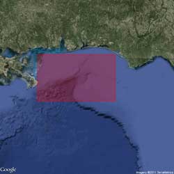
DeSoto Canyon is an erosional valley that cuts
through the broad continental shelf in the northern
part of the Gulf of Mexico.
Much of our knowledge of the physical oceanography of the De Soto Canyon comes from an extensive set of current and hydrographic measurements made from 1997 to 1999 (Berger et al. 2000, Hamilton and Lee 2005). The circulation in the Gulf of Mexico is dominated by the highly variable Loop Current (with an extent ranging from the Florida Straits to the Mississippi River Delta) and associated eddies. These features strongly influence the De Soto Canyon regional flow (Berger et al. 2000, Hamilton and Lee 2005, Schiller et al. 2011). An eastward upper slope surface jet, leading to mean cross-isobath flow at the head of the canyon (100 m), is often accompanied by a westward counter-current (200-500 m) on the Alabama slope. Through analysis of these flows, satellite data, and a numerical model it has been concluded (Wang et al., 2003) that there are two dominant modes of circulation in the De Soto Canyon in water depths greater than 100 m: (1) a "single-eddy" mode in deep water at the foot of the canyon, and (2) an "eddy-pair" mode, with one eddy at the foot of the canyon and the other nearer the head of the canyon. Far field interactions by the Loop Current and associated eddies also affect the De Soto Canyon region and points farther southeast (Weisberg and He, 2003; Walsh et al, 2003, Weisberg et al, 2005).
The head of the De Soto Canyon has three sharp indentations where the conservation of potential vorticity implies strong exchange from off the shelf to the shallow shelf. An efficient transfer of material on and off the shelf is made possible by cyclones and eddies over the head of the canyon and wind-driven flow, including storms and hurricanes (Berger et al. 2000). While the mean flows on the shelf near the De Soto Canyon are mostly a few cm/s or less, low-frequency flows are 10-20 cm/s (Hamilton and Lee 2005, Ohlmann and Niiler 2005, Teague et al. 2007, Carnes et al. 2008). Eddies seem to be driving the circulation, with average velocities between 15 and 30 cm/s. While altimetry-based estimates are extremely useful, the energy derived from these is weaker compared with measurements from drifters, illustrating the turbulent nature of transport processes near the canyon and the key information that Lagrangian drifter and float measurements can provide.
It is hypothesized that a preferential location of exchange and transport of oil will occur at the intersection of the surface and subsurface plume and the canyon. At the surface and within the water column, the topographic steering of the canyon will control the dominant direction of transport and guide oil onshore. Near the head of the canyon, strong vertical motions will combine surface and upwelling waters and inject nutrients into the mixed layer. At depth, near the base of the canyon, focusing of internal waves within the canyon (residual transport up and down-canyon) generated by tides and intermittent lower frequency variability (coastally trapped waves moving around the basin and eddies) will direct the transport of oil-impacted sediment up-canyon to an equilibrium point at some intermediate depth below the head of the canyon. These controls influence the distribution of sediment types and sizes and strongly link the physical and biochemical benthic components.
Deep-C physical oceanographers are focused on determining the physical controls on the dispersion and transport of surface (mainly due to river loads) and subsurface contaminants exerted by the De Soto Canyon geomorphology. The researchers' primary goals are (1) to determine the offshore circulation linkages and mechanisms controlling lateral dispersion, upwelling and downwelling in the De Soto Canyon region; (2) to understand the effects of large-scale stochastic events, such as hurricanes, in the deep sea; (3) to quantify the movement of re-suspended sediments in and near the canyon; and (4) to produce physical observations to constrain and calibrate models of the region.
Any release of oil in the deep Gulf will result in the spreading of hydrocarbons at several levels, due to buoyant plumes, and to the settling of heavy components. Assessing the frequency of sediment re-suspension and determining the dominant process responsible for currents that reach the sediment suspension threshold in the canyons is critical to this portion of the study, particularly as it relates to the transport of carbon within the canyon. In general, the conduit for sediment is the central canyon axis. Sediment is expected to drop off the shelf in a density current and flow down the axis into deeper water, settling at a variety of depths due to variations in bottom slope. Within the axis, tides can be the dominant cause for sediment re-suspension; subsequent dispersion may also be related to larger-scale currents associated with coastal trapped waves, mesoscale eddies, or the Loop Current.
Finally, defining the oceanic response to the passage of storms, especially tropical storms, is a key element in determining oil movement and impact. While attention has focused on the upper ocean response (Halliwell et al. 2011), deeper ocean responses are important, particularly around the De Soto Canyon (Shay and Elsberry 1987, Teague et al. 2007). Indeed, deep sea oceanic momentum and thermal responses have been detected to 1000 m or more. Such a deep response is fundamentally important to a subsurface oil spill where it has been suggested that oil and hydrocarbons may be located at various depths. In addition to possible bottom scouring of pipelines by hurricane-induced current response, the upwelling process can bring subsurface oil to the surface layer. This process is accentuated by Ekman divergence pushing surface water away from the storm center as the storm slows or stalls. These processes are being assessed as part of the Deep-C project with observations and model parameterization studies in the De Soto Canyon to adequately represent the impact of extreme events.
Sources:
Berger, J. T., J. H. Churchill, P. Hamilton, R. Leben, T. n. Lee, W. Sturges, and J. J. Singer. 2000. DeSoto Canyon Eddy Intrusion Study, Final Report Volume II.275. U.S. Department of the Interior, Minerals Management Service, Gulf of Mexico OCS Region, New Orleans, LA.
Carnes, M. R., W. J. Teague, and E. Jarosz. 2008. Low-frequency current variability observed at the shelfbreak in the northeastern Gulf of Mexico: November 2004-May 2005. Continental Shelf Research 28:399-423.
Halliwell, G. R., L. K. Shay, J. Brewster, and W. J. Teague. 2011: Evaluation and sensitivity analysis to an ocean model response to hurricane Ivan. Mon. Wea. Rev., 139(3), 921-945.
Hamilton, P. and T. N. Lee. 2005. Eddies and jets over the slope of the northeast Gulf of Mexico. Pages 123-142 in W. Sturges and A. Lugo-Fernandez, editors. Circulation in the Gulf of Mexico: Observations and Models. Geophysical Monograph Series, Washington DC.
Ohlmann, J. C. and P. P. Niiler. 2005. Circulation over the continental shelf in the northern Gulf of Mexico. Progress in Oceanography 64:45-81.
Schiller, R.V. and V.H. Kourafalou. 2010. Modeling river plume dynamics with the Hybrid Coordinate Ocean Model. Ocean Modeling, doi:10.1016/j.ocemod.2009.12.005.
Shay, L. K. and R. L. Elsberry. 1987. Near-inertial ocean current response to hurricane Frederic. Journal of Physical Oceanography 17:1249-1269.
Teague, W. J., E. Jarosz, D. W. Wang, and D. A. Mitchell. 2007. Observed oceanic response over the uper continental shelf and outer shelf during hurricane Ivan. Journal of Physical Oceanography 37:2181-2206.
Walsh, J. J., et al. 2003. Phytoplankton response to intrusions of slope water on the West Florida Shelf: Models and observations, J. Geophys. Res., 108(C6), 3190, doi:10.1029/2002JC001406.
Wang, D. P., L. Y. Oey, T. Ezer, and P. Hamilton. 2003. Near-surface currents in DeSoto Canyon (1997–99): Comparison of current meters, satellite observations, and model simulation. J. Phys. Oceanogr. 33.
Weisberg, R.H. and R. He. 2003. Local and deep-ocean forcing contributions to anomalous water properties on the West Florida Shelf. J. Geophys. Res., 108, C6, 15, doi:10.1029/2002JC001407.
Weisberg, R.H., R. He, Y. Liu, and J.I. Virmani. 2005. West Florida shelf circulation on synoptic, seasonal, and inter-annual time scales, in Circulation in the Gulf of Mexico, W. Sturges and A. Lugo-Fernandez, eds., AGU monograph series, Geophysical Monograph 161, 325-347.
Deep-C was a four-year, interdisciplinary study of deep sea to coast connectivity in the northeastern Gulf of Mexico.Deep-C is no longer an active research project. The information on this website is for historical reference purposes only.
Home | About Us | Research Areas | Data Center | News & Multimedia | Education & Outreach
© Deep-C Consortium. All Rights Reserved.
This research was made possible by a grant fromThe Gulf of Mexico Research Initiative (GoMRI).
Copyright | Disclaimer | Privacy Policy