 |
 |
RESEARCHERS
 |
Ian MacDonald (Lead) Florida State University |
 |
Albert Hine University of South Florida |
 |
Stan Locker University of South Florida |
Geomorphology and Habitat Classification
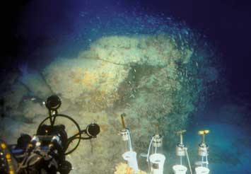
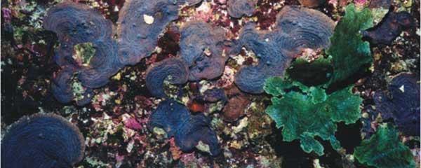
A thorough understanding of the geology, topography, and fine-scale morphology of the sea floor provides the foundation upon which the Deep-C study is developed. Despite a number of descriptions of the geology and bathymetry of this region (see Harbison 1968, Shipp and Hopkins 1978, Brunner and Keigwin 1981, Benson et al. 1997, Gardner et al. 2007), there are far more data available for the central and western Gulf (where energy extraction occurs) than there are for the eastern Gulf. Indeed, the eastern Gulf remains largely unmapped (particularly to the south), the geomorphology inadequately described, and the prevalence of shallow hazard and sub bottom structures unknown. The Deep-C Consortium relies on the best currently available data (including geophysical data produced by the oil and gas industry) on slope morphology to define transect pathways that cover representative sites of deep-sea sedimentary regime — the "foundation" of the benthic environment (e.g., burrows, drift sediments, marine snow or benthic storm events); erosive or depositional features (slump or debris flow); underlying geology; and the presence of natural hydrocarbon seeps, oil and gas vents, gas hydrates, chemosynthetic communities, mud volcano or brine flow, and reef communities.
There are three reasons that compel Deep-C researchers to revisit basic mapping and descriptive studies of the sea floor in this region: (1) oil from the DwH oil spill propagated toward the Alabama and Florida coasts in both cross-slope and along-canyon trajectories through a specific feature of the area, the De Soto Canyon, so there is a need to understand the mechanism by which this occurred; (2) the region is considered a hotspot of biological diversity and has the highest biological productivity in the Gulf of Mexico so it has tremendous economic value; and (3) future energy development will be situated in the region due to the known presence of hyrdocarbon resources.
The Geomorphology component of Deep-C research will focus on producing robust site descriptions, coupling the morphological and (where possible) geophysical characteristics to estimate the spatial extent of surveyed features. These results can be used to hindcast estimates of damage resulting from past oil spills and forecast vulnerabilities of key communities to future spills or other extreme events. The overall intent of this work is: (1) to map, characterize, and quantify the underlying geology and the distribution and abundance of benthic environments, including natural hydrocarbon seeps, hard ground, deep-sea coral communities, and essential fish habitats throughout this region; and (2) to understand the modern depositional system by comparing the areas in which deposition and erosion are actually observed with those areas predicted by circulation models. A secondary component of this work is the investigation of water column anomalies.
Sources:
Benson, D. J., W. W. Schroeder, and A. W. Shultz. 1997. Sandstone hardbottoms along the western rim of De Soto Canyon, northeast Gulf of Mexico. Transactions Gulf Coast Association Geological Societies 47:43-48.
Brunner, C. A. and L. D. Keigwin. 1981. Late neogene biostratigraphy and stable isotope stratigraphy of a drilled core from the Gulf of Mexico Marine Micropaleontology 6:397-418.
Gardner, J. V., B. R. Calder, J. E. H. Clarke, L. A. Mayer, G. Elston, and Y. Rzhanov. 2007. Drowned shelf-edge deltas, barrier islands and related features along the outer continental shelf north of the head of De Soto Canyon, NE Gulf of Mexico. Geomorphology 89:370-390.
Harbison, R. N. 1968. Geology of De Soto Canyon. Journal of Geophysical Research 73:5175-&.
Shipp, R. L. and T. S. Hopkins. 1978. Physical and biological observations of the northern rim of the De Soto Canyon made from a research submersible. Northeast Gulf Science 2:113-121.
Deep-C was a four-year, interdisciplinary study of deep sea to coast connectivity in the northeastern Gulf of Mexico.Deep-C is no longer an active research project. The information on this website is for historical reference purposes only.
Home | About Us | Research Areas | Data Center | News & Multimedia | Education & Outreach
© Deep-C Consortium. All Rights Reserved.
This research was made possible by a grant fromThe Gulf of Mexico Research Initiative (GoMRI).
Copyright | Disclaimer | Privacy Policy