Asphalt in the Seep Ecosystem
Discovering the nature of asphalt deposits in the Gulf of Mexico
By Dr. Ian MacDonald, Florida State University
 Deep-C Scientist Dr. Ian MacDonald |
|
|
October 27, 2012 -- Natural hydrocarbon seeps are a common feature of the Gulf of Mexico. At most seeps, liquid oil and gas escape from reservoirs kilometers below the seafloor, migrate up through faults created by the movement of salt domes, and bubble into the water. Bacteria are able to utilize the oil and gas as a source of nutritive carbon, while dense ecosystems of invertebrates including tube worms and mussels are in turn supported by the bacteria. The break-down of oil and gas at seeps results in layers of carbonate rock, which gradually accumulate as the bacteria produce excess CO2. At other seeps, discharge of oil and gas is associated with dense brines, many times saltier than seawater, that forms from dissolving salt domes and forms pools and rivers on the seafloor. In systems that are highly pressurized and relatively open, oil, gas, brine and mud can erupt in so-called mud volcanoes. So, seeps comprise complex geological, chemical, and biological systems in the deep sea.
In 2003, while exploring the oil seeps in the southern Gulf of Mexico with collaborators from the German research group MARUM, I discovered a different style of seep (MacDonald, Bohrmann et al. 2004). We were exploring a mound in water depths of about 3400 m using a lowered camera platform with a live video feed. After several fruitless hours of watching a relatively featureless ocean bottom pass under the camera, we were shocked out of our chairs when a huge black mass of lava-like material suddenly appeared on the video screen and remained in view for over a minute as the camera platform continued to track along the bottom. It was unlike anything any of us had seen, but around the edges were tube worms and bivalve shells familiar from Gulf of Mexico seeps. We would eventually determine that the black material was asphalt, similar to the tar-like material familiar from the the La Brea tar pit, but never before seen in the deep sea. We named the process asphalt volcanism and it would subsequently be observed offshore California and in the northern Gulf of Mexico as well. Unlike previously known oil and gas seeps, asphalt volcanoes directly create massive substrate — they literally pave the seabed.
|
|
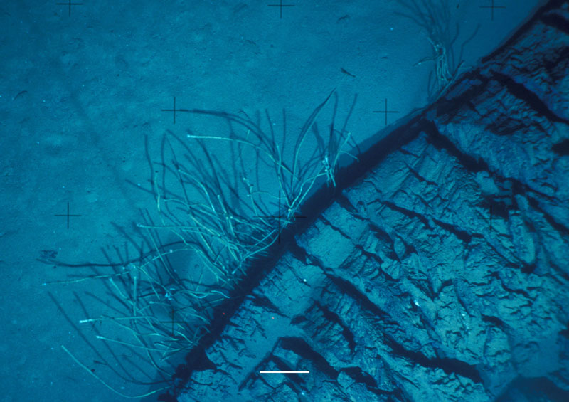
 Asphalt extrustion discovered at 2,200 meters during a survey of opportunity made to ground-truth bubble plumes observed by NOAA Ocean Exploration.
 |
|
During the recent Deep-C cruise on the RV Weatherbird (read the Cruise Blog), I had a moment of déjà vu. Once again our team was using a deep sea camera platform to explore a mound deep below the surface. On this occasion, we were working at about 2200 m depth on a small mound we named Peanut. Previous work by the Ocean Exploration team in 2011 had identified bubble plumes rising from this site. Although it was not in our original plan, I had decided to take advantage of a few hours of spare time in our busy sampling schedule and explore the bubble plumes that the OE team had identified. This time, we had success almost immediately — which was fortunate because we really only had a couple of hours to spare. The video camera on the FSU/FIO MILET system (modular instrument lander and equipment toolsled) started picking up shells and bacterial mats almost as soon as we got to the bottom. Less than thirty minutes into the survey I spotted the unmistakable shape of a meter-wide asphalt extrusion. This time the image quality was much improved and we had real-time high resolution digital photographs to accompany the video. It was plain that the asphalt was still fairly fresh in several places.
This discovery is the first time asphalt volcanism has been seen in the eastern Gulf of Mexico. Hydrocarbon reservoirs containing asphalt generally represent material of greater geologic age than oil and gas reservoirs. The finding at Peanut Hill is significant because it probably means that hydrocarbons of very different ages present in the eastern Gulf, which is generally thought to contain more recent reservoirs. Asphalt can be a major problem for drillers because it plays havoc with drill bits and tends to flow back into the hole when drill strings are removed to change drill bits. Ecologically, asphalt hosts sessile invertebrates like seafans and sea urchins. Finding asphalt where it was unexpected is a reminder of how little we know about the deep ocean and that every expedition will learn new things.
Dr. Ian MacDonald is a professor at the Florida State University (FSU). He is an oceanographer of deep-ocean extreme communities. The physical settings include natural hydrocarbon seeps, gas hydrates, and mud volcano systems. In his project work, he uses satellite remote sensing to locate natural oil releases on the ocean surface. Specialty cameras provide high resolution and time-series imaging of seep fauna and processes at the ocean floor. GIS techniques are used for assessing biological communities and geologic features with submersibles and towed cameras.
MacDonald, I. R., G. Bohrmann , et al. (2004). "Asphalt volcanism and chemosynthetic life, Campeche Knolls, Gulf of Mexico." Science 304: 999-1002.
The Deep-C consortium is a long-term, interdisciplinary study investigating the environmental consequences of petroleum hydrocarbon release in the deep Gulf of Mexico on living marine resources and ecosystem health. The consortium focuses on the geomorphologic, hydrologic, and biogeochemical settings that influence the distribution and fate of the oil and dispersants released during the Deepwater Horizon accident, and is using the resulting data for model studies that support improved responses to possible future incidents.
Deep-C was a four-year, interdisciplinary study of deep sea to coast connectivity in the northeastern Gulf of Mexico.Deep-C is no longer an active research project. The information on this website is for historical reference purposes only.
Home | About Us | Research Areas | Data Center | News & Multimedia | Education & Outreach
© Deep-C Consortium. All Rights Reserved.
This research was made possible by a grant fromThe Gulf of Mexico Research Initiative (GoMRI).
Copyright | Disclaimer | Privacy Policy