Drifters and Floats: The Past, Present, and Near Future
|
|
Prepared by Stan Cutler, a teacher at Lake Brantley High School in Altamonte Springs, Florida, as part of the Summer 2012 Deep-C “Research Experience for Teachers” program.
Note: For the purpose of this article, the terms “drifter” and “float” are used interchangeably; historically, however, “drifter” has applied to instruments on the surface and “float” to those in the water column.
|
|
In 1872, scientists aboard the RMS Challenger used a float designed specifically to drift passively with the flow of water (National Oceanographic Partnership Program [NOPP] 1998). This was probably one of the earliest attempts to study ocean currents, though sailors have been using a “log line” or knotted rope to measure ship speed or river currents for over 100 years. We’ve come a long way since the early days of measuring currents, especially in the past thirty years, and it appears that the technology in this field will continue to grow in the near future.
The concept of a neutrally-buoyant float to measure subsurface currents was developed independently by Henry Stommel in the U.S. and John Swallow in the U.K. in 1955 (Gould 2002). Around the same time, the use of “messages in a bottle” was beginning to take off. During the 1960’s alone, more than 165,000 bottles were released by ships and planes along the U.S. East Coast, with an estimated 10% return (Woods Hole Oceanographic Institution 2010). As a side note, 61,000 Nike shoes were washed overboard due to a storm off Alaska in 1990, and 1600 (2.6%) were eventually reported by beachcombers (Science Education Through Earth Observation for High Schools, 2012)! Large-scale projects began to have a big impact on float development (and perhaps vice versa), as the Mid-Ocean Dynamics Experiment (MODE) in the late 1960s/early 1970s led to improved detection ranges and transmissions using the SOFAR (Sound Fixing and Ranging) channel. In the 1980s, RAFOS (the inverse of SOFAR) floats started downloading data to the Argos satellite system (Gould 2002), and RAFOS floats are still being used to gather ocean data around the globe.
|
|
At this point, the CTD sensor must be introduced. CTD stands for conductivity-temperature-depth, and these sensors are the primary tools for determining the vital physical properties of sea water. The first “modern” CTD instruments date back to around 1990. Some CTDs are large, heavy devices that are lowered from a ship. These “castings” take several hours, depending on the depth, and involve lowering the probes and rosette wheel to the seafloor, obtaining the measurements (temperature, salinity, and density are almost always obtained, while measurements such as dissolved oxygen and fluorescence may also be made), and retrieving the CTD (often while obtaining water samples at certain depths). Small, low-powered CTD sensors are used on many of the autonomous instruments that are deployed for long time periods. An ADCP (Acoustic Doppler Current Profiler, sometimes called ADP) can also be attached to the CTD package, which records water current velocities for a range of depths (Woods Hole Oceanographic Institution [WHOI] 2010).
So why do oceanographers use drifters and floats? Well, there are many ways to use drifter data, but physical oceanographers mainly use the data to: track ocean currents and eddies; verify data from satellites, such as sea surface temperatures; predict where pollutants would go if dumped or spilled into the sea; and help build models of climate and weather patterns, as well as hurricanes (NOPP 1998). The previously-mentioned RAFOS floats drift with the currents and gyres to track the motion of ocean water. Newer, improved floats like ALACE (Autonomous Lagrangian Circulation Explorer), PALACE (Profiling ALACE), and SOLO (Sounding Oceanographic Lagrangian Observer) led to the ambitious Argo array, which began deployments in 1999 and now includes over 3000 floats. Argo currently uses three models: SOLO, PROVOR (with a newer model called ARVOR), and APEX (Autonomous Profiling Explorer), which replaced PALACE. These are sometimes referred to as “floating CTDs” and are totally autonomous after deployment.
I’ve briefly described some of the major developments and changes in drifters and floats since their initial use. These are not, of course, the only instruments being used to study the oceans. Remotely Operated Vehicles (ROVs) are sophisticated robotic systems that can be controlled from a ship on the surface. If the vehicle does not require an “umbilical” cable, it can be referred to as an AUV (Autonomous Underwater Vehicle), and can be home-based on the seafloor or launched from a ship (WHOI 2010). Profilers like the Expendable Bathythermograph (XBT) can be released from a vessel or an aircraft, and some of these are retrievable. Specialized Polar Profiling Floats drifting at various depths in the Arctic Ocean can find open water in ice-covered regions, and similar floats are being used in the Antarctic region. Ice-sensing algorithms for profiling floats were first used in the Weddell Sea in 2002, and recent floats have a survival rate of around 80% (Wong and Riser 2011). Moorings and Meteorological Sensors are widely used, though the Sensors are mainly measuring across the air-sea interface (WHOI 2010). Satellite instruments are very useful to researchers, particularly in the areas of global ocean circulation and sea level rise. However, “while altimetry-based estimates are extremely useful, the energy derived from these is weaker compared with measurements from drifters, illustrating…the key information that Lagrangian drifter and float measurements can provide” (Speer et al. 2011).
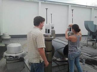
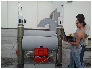
I have been enthralled by having the opportunity to help analyze data from recent cruises in the DeSoto Canyon area, not far from the 2010 Deepwater Horizon explosion and oil spill. I have also greatly enjoyed taking part (well, mostly helping to carry the heavy stuff!) in preliminary telemetry testing of state-of-the-art “bottom drifters.” These drifters will use a Doppler Velocity Log (DVL) system to “look down” at the ocean floor, which may be the first time this has been used with bottom drifters. The telemetry utilizes the Iridium satellite constellation, which consists of 66 satellites in near-polar, low Earth orbits at an altitude of 780 km. Every location on the globe is covered by at least one satellite at all times, which has made it a very popular system. I look forward to following the research based on the drifter data, and seeing the CTD results that will help us better understand the physical oceanography of the DeSoto Canyon.
Sources:
- Gould, W.J. (2002). A brief history of float developments. Southampton Oceanography
Centre. Retrieved from http://www.noc.soton.ac.uk/JRD/HYDRO/argo/history.php - National Oceanographic Partnership Program (1998). Project NOPP Drifters: Partnering Ocean
Science, Education, and Technology. Retrieved from http://drifters.doe.gov/ - Science Education Through Earth Observation for High Schools (2012). Ocean Currents: Nike Trainers
and Rubber Ducks. Retrieved from http://www.seos-project.eu/modules/oceancurrents/oceancurrents-c01-p02.html - Speer, K., Bower, A., Clarke, A., Hamilton, P., Shay, N., Singer, J., Sturges, W., Wienders, N.,
and Weisberg, R. (2011). Physical transport of particulate and dissolved material from the
deep ocean to the coast. Retrieved from http://deep-c.org/phys-oceanography.html - Wong, A.P.S., Riser, S.C. (2011). Profiling Float Observations of the Upper Ocean under Sea Ice
off the Wilkes Land Coast of Antarctica. Journal of Physical Oceanography, 41, 1102-1115.
doi: http://dy.doi.org/10.1175/2011JPO4516.1 - Woods Hole Oceanographic Institution (2010). Floats and Drifters. Retrieved from
http://www.whoi.edu/page.do?pid=10320
Deep-C was a four-year, interdisciplinary study of deep sea to coast connectivity in the northeastern Gulf of Mexico.Deep-C is no longer an active research project. The information on this website is for historical reference purposes only.
Home | About Us | Research Areas | Data Center | News & Multimedia | Education & Outreach
© Deep-C Consortium. All Rights Reserved.
This research was made possible by a grant fromThe Gulf of Mexico Research Initiative (GoMRI).
Copyright | Disclaimer | Privacy Policy