Geologic Beginnings of the Gulf of Mexico with Emphasis on
the Formation of the De Soto Canyon
(Posted August 14, 2013) -- By Albert C. Hine, Shane C. Dunn, and Stanley D. Locker, College of Marine Science, University of South Florida, St. Petersburg, FL 33701
|
|
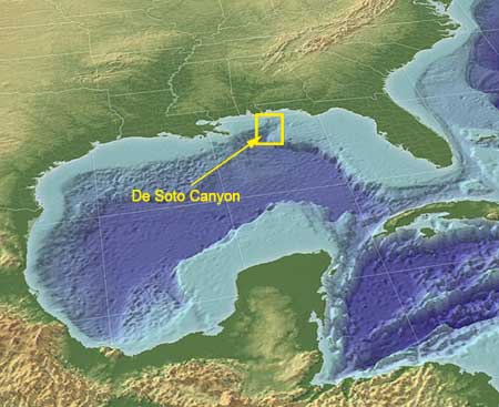 Figure 1. The Gulf of Mexico is a ~3,400 m deep, semi-enclosed ocean basin whose entrance is dominated by two huge carbonate platforms—Yucatan Peninsula/Campeche Bank on the west and the Florida Platform on the east both supporting very wide shallow, submerged shelves. The northern Gulf of Mexico basin is also dominated by one of the largest river deltas in the world — the Mississippi. This small ocean basin also has many salt-movement related structures forming the “dimple-like “bathymetric appearance in the deeper water areas. Note the indentation in the NE section, which is commonly named the De Soto Canyon on most maps and charts. (Illustration credit: Gulfbase.org)
With the research now hitting full stride investigating the effects of the 86-day long BP oil spill triggered by the explosion and sinking of the Deepwater Horizon drilling platform (Macondo Site 252), it seems appropriate to review the geologic history of the Gulf of Mexico (Fig. 1). Here, we do that with a special emphasis on the De Soto Canyon, a feature in the northeastern Gulf of Mexico of particular interest to scientists.
One of the overlooked narratives of the disaster is why there is so much oil and gas in the Gulf of Mexico in the first place, since it is the center of huge investments in exploration and production. Indeed, today, the Gulf of Mexico provides 23% of the total US production of crude oil (US Energy Information Agency), 9% of the world’s oil reserves, and 11% of the world’s reserves (Nehring et al., 1991). Only the Arabian-Iranian Province supplies more. But, offshore drilling is a very fast-moving target worldwide, with reserve and production numbers changing monthly.
Contrary to political statements such as “drill baby drill”, or “drill here, drill there, drill everywhere”, which imply that drilling might occur anywhere, drilling can only be successful where oil and gas are found, and they are found in great abundance only where key geologic factors have allowed their development over geologic time. The key factors are:
- abundant and rich, organic source rocks,
- ideal pressure-temperature-time environments to convert organic matter in the source rock to kerogens and natural gas,
- abundant, highly porous and permeable reservoir rocks for hydrocarbon migration, and
- numerous suitable traps with seals to allow the upward migrating hydrocarbons to accumulate.
Oil and gas can form in trace amounts in many places, but economically-viable accumulations are realized only where these factors combine to form an ideal environment.
The Early Days — 200 to 160 million years ago (Ma)
The Gulf of Mexico, formed by the process of sea-floor spreading, and is considered a true ocean basin1. It formed as part of the complex breakup of the mega-continent Pangea starting about 180 million years ago (Ma), when a 6,000-km long ragged crack split Pangea into two supercontinents, Laurentia (consisting mostly of what is now North America) and Gondwana (consisting of what is now South America and Africa) (Fig. 2).
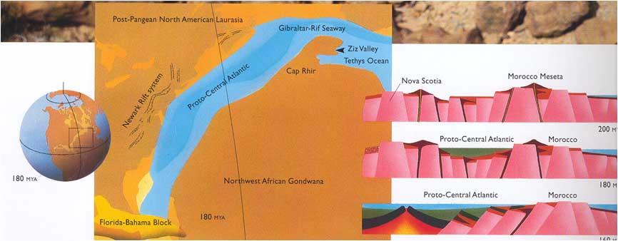
Figure 2. Simplified cartoon illustrating early ocean basin separating North America (Laurentia) from Africa (Gondwana).
This water body was initially called the Tethys Sea and with further widening became the North Atlantic Ocean (modified from Redfern, 2001; Hine, 2013).
Prior to actual breakup, numerous long, narrow-rift basins formed due to extension and stretching of continental crust creating topographically low valleys surrounded by uplands, sometimes mountains, and bounded by large normal faults that were active during the Triassic and Early Jurassic periods, but are no longer active today (Fig. 3). Along the eastern continental margin of North America, they became filled with alluvial fans, deltas, rivers, and lakes, and shallow mud flats famous for their three-toed dinosaur footprints, but not filled with seawater. Some of these basins today control modern topography and drainage such as those in the lower Connecticut and Hudson River valleys. Other basins have been completely filled with non-marine sediments or buried and have little to no modern topographic expression.
|
|
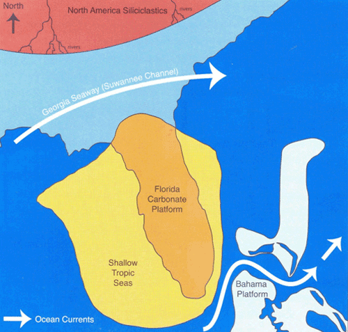 Figure 4. Cartoon illustrating seawater filling in the South Georgia Rift Basin forming the Georgia Seaway (modified from Redfern, 2001; Hine, 2013). |
|
|
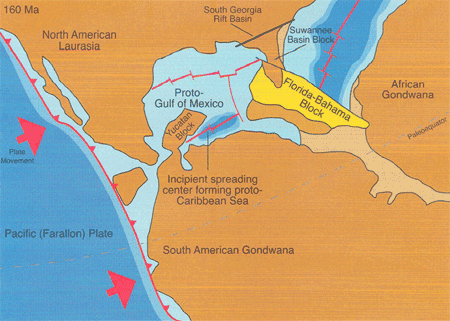 Figure 5. Map illustrating opening on the Gulf of Mexico by movement of the Yucatan Block and Florida-Bahama blocks of continental/transitional crust (modified from Redfern, 2001; Hine, 2013).
 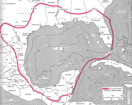 Figure 6. Outline of original Gulf of Mexico basin extending beneath modern land areas. Salt beneath land areas in Texas, Louisiana, Alabama and Florida were deposited in the earlier, much larger Gulf of Mexico Basin (Salvador, 1991).
During this early extension and before the Tethys Sea (the proto-Atlantic Ocean) formed between Laurentia and Gondwana, a significant rift basin formed across South Georgia. This NE-SW trending structure, commonly called the South Georgia Rift Basin2, was probably >500-km long, >100-km wide, and had about 1-km relief. Rifting ceased in this area but seafloor spreading continued to propagate around the peninsula Florida, splitting Laurentia from Gondwana and forming the Tethys Sea, where the southern and western parts became the Caribbean Sea and North Atlantic Ocean. Eventually, the South Georgia Rift Basin flooded with seawater, thus forming a seaway that has been referred to by a number of names—the Georgia Channel System, the Georgia Seaway the Suwannee Channel, and the Gulf Trough (Fig. 4). This seaway separated the Florida Platform from SE North America, allowing carbonate sediments to accumulate in great abundance in Florida without being negatively influenced or even buried by continental sediments being shed off the rapidly eroding southern Appalachian Mountains. The Early Gulf of Mexico—The Emplacement of Salt--160-140 Ma
The seafloor spreading motion moving continental blocks occurred from about 160 to 140 Ma. This process moved the Yucatan Block to the south and the Florida Straits Block (also known as the Florida Bahamas Block) to the southeast, thus creating the Gulf of Mexico basin (Fig. 5). The movement of these blocks of highly-stretched and extended transitional crust (continental crust intruded by oceanic crust-like rocks) eventually created a broad, deep basin still not yet permanently connected to the open ocean or filled with seawater. The primary early connections were to the Pacific Ocean to the west and the proto-Caribbean and Atlantic Ocean to the south and east respectively. Figure 6. Outline of original Gulf of Mexico basin extending beneath modern land areas. Salt beneath land areas in Texas, Louisiana, Alabama and Florida were deposited in the earlier, much larger Gulf of Mexico Basin (Salvador, 1991).
The original Gulf of Mexico basin was much larger than the basin of today, extending north nearly to Oklahoma and west to west Texas (Fig. 6). Most of the original geologic basin filled along the margins with sediments to form land, leaving only a smaller portion of the original basin. As mentioned, the Gulf of Mexico basin also includes the Florida and Yucatan Platforms and their huge, now submerged, shelves.
Seawater poured into the developing Gulf of Mexico basin from the Pacific Ocean through small gaps in the Mexican terrain that would open and close with changes in local tectonics and global sea level. Due to the arid environment of this region, the seawater introduced during these multiple flooding events evaporated to form halite (NaCl) deposits up to 4-km thick. Eventually, the ocean crust formed by continued seafloor spreading, split the salt deposits into two provinces and the entire basin became permanently filled with open-marine, normal salinity seawater (Fig. 7). Sediments from the surrounding land mass began to accumulate on top of the salt (called the Louann Formation) and a huge physically-connected carbonate complex continued to grow (Yucatan-Florida-Bahama Platform). Continued infilling of the Gulf of Mexico basin from the North American continent explains why oil traps associated with salt structures are found well inland today—these traps originally evolved underwater within the earlier Gulf of Mexico basin (see Figs. 6 and 7) but now lie beneath dry land.
The South Georgia Rift Basin also was partially filled with salt—particularly the western end that was connected to the larger Gulf of Mexico developing basin. It was this salt deposit that formed the highly visible diapirs that form topographic highs in the deeper portion of the modern De Soto Canyon.
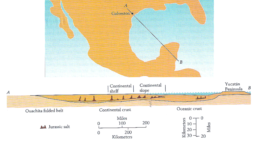
Figure 7. Cross section of the Louann Formation, showing Jurassic salt deposits, which rose into domes in some places because of their low density.(Wilhelm and Dwing 1972).
What is the De Soto Canyon?
|
|
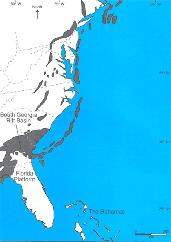
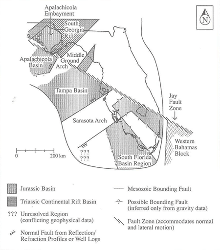 Figure 8. Illustration showing that the Apalachicola Embayment is actually part of the western end of the South Georgia Rift Basin. The De Soto Canyon occupies the western portion of the Apalachicola Embayment. (Smith and Lord, 1997).
Based upon the presence of salt structures in the Apalachicola Embayment, most geoscientists think that the De Soto Canyon is fundamentally an indention in the trend of the west Florida and north Florida shelf. As a a result, the De Soto Canyon represents a modern, but incompletely filled in western portion of the Jurassic South Georgia Rift Basin (Fig. 8)3. Most of the South Georgia Rift Basin and the flooded Georgia Seaway were completely filled by continental sediment eroding from the Appalachian Mountains by the Oligocene (~28 Ma). The Appalachian Mountains are thought to have been as high as the Himalayas when they were first formed. Given that the Himalayas are over 8,000-m high and the present day Appalachians are barely 2,000-m high this suggests that approximately 6,000-m of rock were eroded, transported, and re-deposited over the past 300 Ma. These sediments formed the Mesozoic-Cenozoic continental margins of the southern United States, including much of peninsular Florida. This filling during sea-level lows allowed existing river deltas to migrate from South Georgia to North Florida. Today, one can drive from Florida up through Georgia on roads built on a flat coastal plain that covers the once 100-km wide x 500-km long x 1-km deep basin.
The De Soto Canyon area clearly is part of the Gulf of Mexico megaprovince (Fig. 9). But is it really a canyon? A submarine canyon, traditionally defined in geological oceanography, is a steep-sided (sometimes near vertical walled), narrow feature incised into a submarine slope. It can extend landward onto the continental shelf and seaward to depths of several (2-3) kilometers.
By this definition, the De Soto Canyon, in its broadest sense, is not a submarine canyon similar to the narrow, highly-incised, precipitous, steep-walled features such as the Hudson or Monterey Canyons or the hundreds of other well-known features around the world’s continental slopes considered to be true submarine canyons (Fig. 10). It is, rather, an expansive, gently-sloped, geomorphic indentation in the modern shelf and shelf-slope system that is structurally controlled from below and represents the last unfilled segment of a huge Jurassic rift 3.3
The details of this interpretation are the subject of the Ph. D. dissertation research of graduate student Mr. Shane Dunn at the University of South Florida, College of Marine Science.
The modern De Soto Canyon contains a network of smaller canyons (many are more channel-like than canyon like, given that the maximum relief of its canyons is ~100 m—and most are much smaller) that will contribute sediment to its ultimate infill sometime in the geologic future. The De Soto Canyon also marks the long-term physical transition from the continental, siliciclastic sedimentary regime dominated by rivers along the north to the carbonate sedimentary regime dominated by shallow (pre mid-Cretaceous) and deeper water benthic and planktonic input (post mid-Cretaceous) to the south. Perhaps a more accurate term for this geologic feature is the De Soto Embayment.
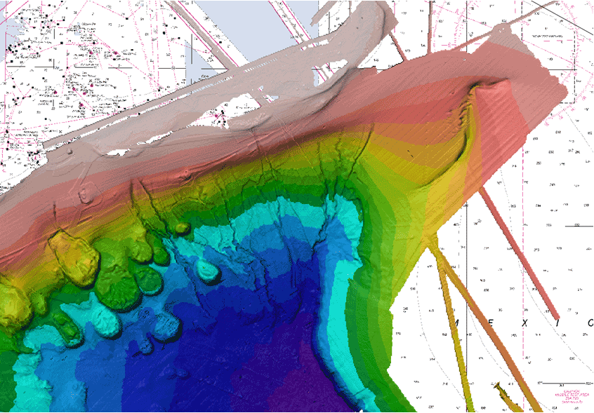
Figure 9. Multibeam image of numerous small downslope channels distributed within the broader De Soto Canyon indention
(Source: Source map data from NGDC--National Geophysical Data Center, includes Okeanos and other multibeam data - Dr. Stanley D. Locker).
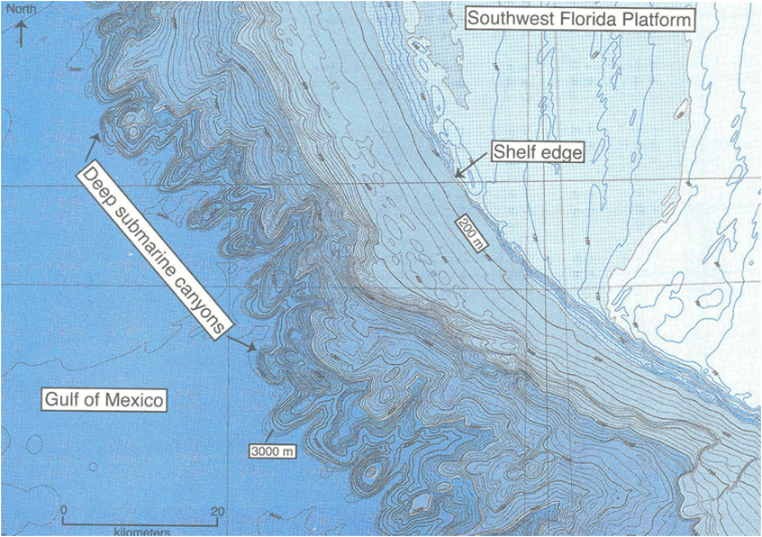
Figure 10. Submarine canyon complex along the base of the southwest Florida Platform. Some canyons have ~2 km of relief. These are headward-eroding, high-relief, steep-sided
features that fit the classic definition of submarine canyon (NOAA National Ocean Survey map; Hine, 2013).
The De Soto Canyon in the Icehouse World—2.5 Ma to present
From the mid-Late Cretaceous (70 Ma) to the late Pliocene-early Pleistocene (~2.5 Ma) the Earth transitioned from a Greenhouse Earth--driven by very high CO2 concentrations in the atmosphere that resulted in a very warm Earth with persistently high sea level--to an Earth that first accumulated a permanent ice sheet on Antarctica (beginning ~45 Ma). By ~2.5 to present the Earth experienced high-frequency (23, 41, and 100 kya cycles; the well-known Milankovitch Cycles) glacial/interglacial events marked by the waxing and waning of the great northern hemisphere Laurentide and Fenno-Scandanavian ice sheets. Global sea levels fluctuated many dozens of times from ~50 to ~150 m amplitude during this latter period. We are still experiencing an Icehouse Earth, although at an interglacial stage having just come out of a the Last Glacial Maximum ending about 18 ka (18 thousand years ago) when sea level was about 120-125 m lower than present-day sea level.
The long-term transition from Greenhouse to Icehouse Earth, particularly in the past ~2.5 Ma, must have fundamentally changed the style of sedimentary infilling in the De Soto Canyon embayment. This transition and the nature of infilling resulting from many high frequency, high amplitude sea-level fluctuations that rarely occurred on the Greenhouse Earth is largely unknown3. However, the imagery shown in Figure 9 clearly reveals erosive events creating a complex series of channels (small canyons) that accommodated transfer of sedimentary material from the upper slope or even the outer shelf to the base of the De Soto Canyon embayment. When and under what conditions this sedimentary transfer occurred creating this incised channel network is not known. Possibly, during sea-level highstands, infilling was not channelized and finer-grained sediments accumulated whereas during sea-level lowstands and stillstands, infill was coarser-grained and more channelized. But, existing published, deeper penetrating seismic data and unpublished industry-based data do not indicate that the De Soto Canyon is a long-term erosional feature that is incising landward. Rather, it is a broad sedimentary basin that has undergone long-term infilling prograding seaward only interrupted by short-term, relatively small-scale erosional events.
Endnotes
1Other large bodies of water such as Hudson Bay, while geographically large, are not considered ocean basins because they did not form by seafloor-spreading tectonics. These are considered shallow, epicontinental (defined as “up on the continent”) seas that filled with seawater flooding large areas on top of continental rocks generally sea-level highstands.
2We maintain that the western end of this structural feature underlies and controls the location of the modern De Soto Canyon.
Acknowledgments
We thank Dr. Felicia Coleman for the wonderful review, which greatly helped to change the geologic prose to one more understandable for the general reading public. We thank Tracy Ippolito for additional editing, her patience, and her help while we generated this document.
References
Hine, A.C., 2013, Geologic History of Florida—Major Events That Formed the Sunshine State: Gainesville, FL, University Press of Florida, 229p.
Klitgord,K.D., and D. R. Hutchinson, 1988, US Atlantic Continental Margin: Structural and Tectonic Framework, in, R.E. Sheridan and J.A. Grow, eds., The Atlantic Continental Margin, Boulder, CO, Geological Society of America, p. 19-55.
Nehring, R., 1991, Oil and gas resources, in Salvador, A., ed., The Gulf of Mexico Basin: Boulder, CO, Geological Society of America., The Geology of North America, v., J, p. 445-494.
Redfern, R., 2001, Origins: The Evolution of Continents and Life: Norman; University of Oklahoma Press by special arrangement with Cassell and Co. UK.
Salvador, A., 1991, Origin and development of the Gulf of Mexico basin, in, Salvador, A., ed., The Gulf of Mexico Basin: Boulder, Colorado, Geological Society of America, The Geology of North America, v. J, p. 389-444.
Smith, D.L., and Lord, K.M., 1997, Tectonic evolution and geophysics of the Florida Basement, in, Randazzo, A.F., and Jones, D.S., eds., Gainesville, FL The Geology of Florida: University of Florida Press, p. 13-37.
Wilhelm, O., and Dwing, M., 1972, Geological Society of America Memoir 83.
The Deep-C (Deep Sea to Coast Connectivity in the Eastern Gulf of Mexico) Consortium is a long-term, interdisciplinary study of deep sea to coast connectivity in the northeastern Gulf of Mexico. The study is investigating the environmental consequences of petroleum hydrocarbon release in the deep Gulf on living marine resources and ecosystem health. Deep-C research is made possible by a grant from BP/The Gulf of Mexico Research Initiative. Drs. Albert Hine and Stan Locker are Deep-C researchers.
 |
Dr. Albert Hine is a broadly-trained geological oceanographer who has addressed sedimentary geology/stratigraphy problems from the estuarine system out to the base of slope—primarily in carbonate or mixed siliciclastic/carbonate environments. His associates, graduate students, and he have defined the response of coastal and shelf depositional systems to sea-level fluctuations, climate changes, western boundary currents, antecedent topography, and sediment supply. Specifically this includes geologic origin and evolution of submerged paleo-shorelines, reefs (relict and active), shelf sand bodies, open marine marsh systems, barrier islands, and back-barrier environments and how they might have interacted with each other in the past. He also has been heavily involved in scientific ocean drilling and have sailed on the JOIDES Resolution (Co-chief scientist—Leg 182, and sedimentologist—Leg 194). Both legs examined carbonate sedimentation along continental margins. Dr. Hine has been co-chief scientist on more than 75 research cruises including the Southern Ocean, Coral Sea, Bahamas, Bermuda, US east coast, Caribbean Sea, and Gulf of Mexico.
 |
Dr. Stan Locker is research scientist of marine geology and geophysics at the University of South Florida. His research interests include sequence stratigraphy and sedimentary processes of continental margins from the deep ocean to coastal environments. Investigations often focus on understanding the response of depositional systems to sea-level change and the resultant sedimentary facies and stratal architecture. Field techniques include high-resolution seismic reflection imaging, side-scan sonar and other acoustic remote sensing methods, integrated with sedimentological data from cores or other sampling. Recent studies have addressed Holocene coastal evolution, climate and sea-level change, hydrostratigraphy, karst deformation of the Florida Platform, continental shelf sedimentation, deep-water and relic reef systems, geostrophic current-controlled sedimentation, and benthic habitat classification.
Deep-C was a four-year, interdisciplinary study of deep sea to coast connectivity in the northeastern Gulf of Mexico.Deep-C is no longer an active research project. The information on this website is for historical reference purposes only.
Home | About Us | Research Areas | Data Center | News & Multimedia | Education & Outreach
© Deep-C Consortium. All Rights Reserved.
This research was made possible by a grant fromThe Gulf of Mexico Research Initiative (GoMRI).
Copyright | Disclaimer | Privacy Policy