Research Areas
Physical transport of particulate and dissolved material from the deep ocean to the coast
DeSoto Canyon is an erosional valley that cuts
through the broad continental shelf in the northern
part of the Gulf of Mexico.
Much of our knowledge of the physical oceanography of the De Soto Canyon comes from an extensive set of current and hydrographic measurements made from 1997 to 1999 (Berger et al. 2000, Hamilton and Lee 2005). The circulation in the Gulf of Mexico is dominated by the highly variable Loop Current (with an extent ranging from the Florida Straits to the Mississippi River Delta) and associated eddies. These features strongly influence the De Soto Canyon regional flow (Berger et al. 2000, Hamilton and Lee 2005, Schiller et al. 2011). An eastward upper slope surface jet, leading to mean cross-isobath flow at the head of the canyon (100 m), is often accompanied by a westward counter-current (200-500 m) on the Alabama slope. Through analysis of these flows, satellite data, and a numerical model it has been concluded (Wang et al., 2003) that there are two dominant modes of circulation in the De Soto Canyon in water depths greater than 100 m: (1) a "single-eddy" mode in deep water at the foot of the canyon, and (2) an "eddy-pair" mode, with one eddy at the foot of the canyon and the other nearer the head of the canyon. Far field interactions by the Loop Current and associated eddies also affect the De Soto Canyon region and points farther southeast (Weisberg and He, 2003; Walsh et al, 2003, Weisberg et al, 2005).
The head of the De Soto Canyon has three sharp indentations where the conservation of potential vorticity implies strong exchange from off the shelf to the shallow shelf. An efficient transfer of material on and off the shelf is made possible by cyclones and eddies over the head of the canyon and wind-driven flow, including storms and hurricanes (Berger et al. 2000). While the mean flows on the shelf near the De Soto Canyon are mostly a few cm/s or less, low-frequency flows are 10-20 cm/s (Hamilton and Lee 2005, Ohlmann and Niiler 2005, Teague et al. 2007, Carnes et al. 2008). Eddies seem to be driving the circulation, with average velocities between 15 and 30 cm/s. While altimetry-based estimates are extremely useful, the energy derived from these is weaker compared with measurements from drifters, illustrating the turbulent nature of transport processes near the canyon and the key information that Lagrangian drifter and float measurements can provide.
It is hypothesized that a preferential location of exchange and transport of oil will occur at the intersection of the surface and subsurface plume and the canyon. At the surface and within the water column, the topographic steering of the canyon will control the dominant direction of transport and guide oil onshore. Near the head of the canyon, strong vertical motions will combine surface and upwelling waters and inject nutrients into the mixed layer. At depth, near the base of the canyon, focusing of internal waves within the canyon (residual transport up and down-canyon) generated by tides and intermittent lower frequency variability (coastally trapped waves moving around the basin and eddies) will direct the transport of oil-impacted sediment up-canyon to an equilibrium point at some intermediate depth below the head of the canyon. These controls influence the distribution of sediment types and sizes and strongly link the physical and biochemical benthic components.
Deep-C physical oceanographers are focused on determining the physical controls on the dispersion and transport of surface (mainly due to river loads) and subsurface contaminants exerted by the De Soto Canyon geomorphology. The researchers' primary goals are (1) to determine the offshore circulation linkages and mechanisms controlling lateral dispersion, upwelling and downwelling in the De Soto Canyon region; (2) to understand the effects of large-scale stochastic events, such as hurricanes, in the deep sea; (3) to quantify the movement of re-suspended sediments in and near the canyon; and (4) to produce physical observations to constrain and calibrate models of the region.
Any release of oil in the deep Gulf will result in the spreading of hydrocarbons at several levels, due to buoyant plumes, and to the settling of heavy components. Assessing the frequency of sediment re-suspension and determining the dominant process responsible for currents that reach the sediment suspension threshold in the canyons is critical to this portion of the study, particularly as it relates to the transport of carbon within the canyon. In general, the conduit for sediment is the central canyon axis. Sediment is expected to drop off the shelf in a density current and flow down the axis into deeper water, settling at a variety of depths due to variations in bottom slope. Within the axis, tides can be the dominant cause for sediment re-suspension; subsequent dispersion may also be related to larger-scale currents associated with coastal trapped waves, mesoscale eddies, or the Loop Current.
Finally, defining the oceanic response to the passage of storms, especially tropical storms, is a key element in determining oil movement and impact. While attention has focused on the upper ocean response (Halliwell et al. 2011), deeper ocean responses are important, particularly around the De Soto Canyon (Shay and Elsberry 1987, Teague et al. 2007). Indeed, deep sea oceanic momentum and thermal responses have been detected to 1000 m or more. Such a deep response is fundamentally important to a subsurface oil spill where it has been suggested that oil and hydrocarbons may be located at various depths. In addition to possible bottom scouring of pipelines by hurricane-induced current response, the upwelling process can bring subsurface oil to the surface layer. This process is accentuated by Ekman divergence pushing surface water away from the storm center as the storm slows or stalls. These processes are being assessed as part of the Deep-C project with observations and model parameterization studies in the De Soto Canyon to adequately represent the impact of extreme events.
Sources:
Berger, J. T., J. H. Churchill, P. Hamilton, R. Leben, T. n. Lee, W. Sturges, and J. J. Singer. 2000. DeSoto Canyon Eddy Intrusion Study, Final Report Volume II.275. U.S. Department of the Interior, Minerals Management Service, Gulf of Mexico OCS Region, New Orleans, LA.
Carnes, M. R., W. J. Teague, and E. Jarosz. 2008. Low-frequency current variability observed at the shelfbreak in the northeastern Gulf of Mexico: November 2004-May 2005. Continental Shelf Research 28:399-423.
Halliwell, G. R., L. K. Shay, J. Brewster, and W. J. Teague. 2011: Evaluation and sensitivity analysis to an ocean model response to hurricane Ivan. Mon. Wea. Rev., 139(3), 921-945.
Hamilton, P. and T. N. Lee. 2005. Eddies and jets over the slope of the northeast Gulf of Mexico. Pages 123-142 in W. Sturges and A. Lugo-Fernandez, editors. Circulation in the Gulf of Mexico: Observations and Models. Geophysical Monograph Series, Washington DC.
Ohlmann, J. C. and P. P. Niiler. 2005. Circulation over the continental shelf in the northern Gulf of Mexico. Progress in Oceanography 64:45-81.
Schiller, R.V. and V.H. Kourafalou. 2010. Modeling river plume dynamics with the Hybrid Coordinate Ocean Model. Ocean Modeling, doi:10.1016/j.ocemod.2009.12.005.
Shay, L. K. and R. L. Elsberry. 1987. Near-inertial ocean current response to hurricane Frederic. Journal of Physical Oceanography 17:1249-1269.
Teague, W. J., E. Jarosz, D. W. Wang, and D. A. Mitchell. 2007. Observed oceanic response over the uper continental shelf and outer shelf during hurricane Ivan. Journal of Physical Oceanography 37:2181-2206.
Walsh, J. J., et al. 2003. Phytoplankton response to intrusions of slope water on the West Florida Shelf: Models and observations, J. Geophys. Res., 108(C6), 3190, doi:10.1029/2002JC001406.
Wang, D. P., L. Y. Oey, T. Ezer, and P. Hamilton. 2003. Near-surface currents in DeSoto Canyon (1997–99): Comparison of current meters, satellite observations, and model simulation. J. Phys. Oceanogr. 33.
Weisberg, R.H. and R. He. 2003. Local and deep-ocean forcing contributions to anomalous water properties on the West Florida Shelf. J. Geophys. Res., 108, C6, 15, doi:10.1029/2002JC001407.
Weisberg, R.H., R. He, Y. Liu, and J.I. Virmani. 2005. West Florida shelf circulation on synoptic, seasonal, and inter-annual time scales, in Circulation in the Gulf of Mexico, W. Sturges and A. Lugo-Fernandez, eds., AGU monograph series, Geophysical Monograph 161, 325-347.
The Earth System Model
Prediction of the fate of oils, such as those released during the Deepwater Horizon (DwH) oil spill, and their impact (both local and distant) on the environment not only requires detailed knowledge of the Gulf of Mexico 3D circulation (basin-wide and shelf/coastal processes), but also knowledge of the surface winds, waves, sediments, and biogeochemistry. The ocean, atmosphere, land, and biosphere are interconnected in fundamental ways that ensure changes in one realm will reverberate throughout all others.
So there is a need to develop a comprehensive model with the capability to forecast the pathways along which such exchanges occur and predict the level of risk associated with specific outcomes. The Deep-C Consortium is developing this kind of model through the expertise of two teams of experts — the first team focusing on the provision of historical and newly acquired field data in the northeastern Gulf of Mexico to the second team, whose focus is on the Earth System Model prediction system development and validation.
Coupled ocean-atmosphere-wave component – At the heart of the Earth System Model is the coupled ocean-atmosphere-wave component. This component consists of the U.S. Navy's Coupled Ocean–Atmosphere Mesoscale Prediction System (COAMPS) configured for the Gulf of Mexico by the Naval Research Laboratory at the Stennis Space Center. The atmospheric portion of COAMPS consists of a complete three-dimensional data assimilation system that includes data quality control, analysis, initialization, and forecast model components. The nonhydrostatic atmospheric model includes predictive equations for the momentum, the non-dimensional pressure perturbation, the potential temperature, the turbulent kinetic energy, and the mixing ratios of water vapor, clouds, rain, ice, grauple, and snow, and contains advanced parameterizations for boundary layer processes, precipitation, and radiation. Deep-C uses the HYbrid Coordinate Ocean Model (HYCOM) as the ocean component. This model was developed through the HYCOM consortium of academic, private, and government organizations, led by Florida State University in close interaction with the Naval Research Laboratory and the Rosenstiel School of Marine and Atmospheric Sciences. The model proved critically important for monitoring and forecasting activities related to the deep sea oil and dispersant plumes during the DwH oil spill. Understanding the movement of these plumes requires highly accurate portrayal of ocean currents at depths below the influence of the Loop Current itself, above and below the depth of the wellhead (~ 1500m).
The Earth System modeling approach represents an area of emerging research, especially at regional scales following methods developed for global climate models. It addresses the coupled impacts of frontal passages as well as of extreme events such as hurricanes, droughts, and floods that are influenced by atmospheric conditions. Another area of importance is the development of a strong understanding of the impact of riverine influence on primary production and sedimentology. Deep-C is investigating the transport and fate of riverine waters (and associated materials) under the influence of shelf and offshore circulation and topographic effects; interaction among different plume systems and along-shelf and cross-marginal transport; scenarios of climatic and/or anthropogenic influence on river flows; influence of shelf circulation on particle transport; freshwater budgets and flushing times in the bays.
Wave component – The wave modeling component is based on WaveWatch III — a third-generation wave model that solves the random phase spectral action density balance equation for wavenumber-direction spectra. The role of wave-ocean coupling is to parameterize the wave-current interactions in the water column, to improve the parameterization of the surface and bottom shear stresses, and finally to improve the model predictions for the transported scalars (sediments, oil, etc).
Sediment component — The sediment component of this research is based on the Community Sediment Transport Modeling System (CSTMS) and will be two-way coupled with the ocean-atmosphere-wave module via the water/mixture density field and the bottom shear stresses. Sediment maps created from archived and measured data can be used to initialize the sediment model.
Biogeochemical component — The biogeochemical model is based on the multi-component COSINE (Carbon, Silicate, Nitrogen Ecosystem) of F. Chai. The model is being modified to include additional constituents of interest such as methane and heavy metals. Although biogeochemistry typically has only a small influence on the physics of the Earth System Model (primarily through impacts on the penetration of solar radiation into the ocean, and modification of water density by suspended solids), this model allows a two-way coupling of all the modeling components, thereby facilitating a better understanding of the impacts of oil on the physical environment and ecosystems.
Oil modeling component — A state-of-the art 3D oil spreading and weathering model is being used to estimate the fate of the discharged oil. In this model, oil is represented as a cloud of droplets (particles) whose trajectory and composition is calculated based on time and space varying, meteorological, oceanographic and other pertinent environmental conditions derived from the measurements and the Earth System Model. Oil droplets are modeled as a composite of several fractions with different chemical properties, and each particle carries a set of properties including position, mass, volume, density, chemical properties etc. which can vary with both time and space.
The oil fate and transport model will be used to calculate the far field spreading and weathering of oil droplets resulting from the break-up of the near-field plume. The goal is to obtain a probabilistic estimation of the oil fate and to provide a more complete quantification uncertainty in the oil fate of the discharged. This research considers how uncertainties in ocean circulation model inputs and uncertainties in the physical, chemical and biological characteristics of the oil affect the fate of the oil discharged. Satellite bio-optical products are used to characterize the oil dispersions from ocean surface observations. These valuable tools for monitoring ocean surface properties are an indispensable complement to the ocean models which use them for validation, initialization, and background (relaxation) fields. Light absorption characteristics in seawater can be used to infer oil concentrations and dispersion at the surface while the modeling component "adds" the subsurface structure to provide a full environmental characterization. The ocean model, with an oil-like tracer implementation, along with the satellite data, can be used to support field experiments and to provide high-resolution environmental predictions. Additionally, a web-based interface is being developed that will allow for on-the-fly oil prediction using the Earth System Model forecasts. Deep-C plans to introduce this interface in mid-2012.
Geomorphology and Habitat Classification
A thorough understanding of the geology, topography, and fine-scale morphology of the sea floor provides the foundation upon which the Deep-C study is developed. Despite a number of descriptions of the geology and bathymetry of this region (see Harbison 1968, Shipp and Hopkins 1978, Brunner and Keigwin 1981, Benson et al. 1997, Gardner et al. 2007), there are far more data available for the central and western Gulf (where energy extraction occurs) than there are for the eastern Gulf. Indeed, the eastern Gulf remains largely unmapped (particularly to the south), the geomorphology inadequately described, and the prevalence of shallow hazard and sub bottom structures unknown. The Deep-C Consortium relies on the best currently available data (including geophysical data produced by the oil and gas industry) on slope morphology to define transect pathways that cover representative sites of deep-sea sedimentary regime — the "foundation" of the benthic environment (e.g., burrows, drift sediments, marine snow or benthic storm events); erosive or depositional features (slump or debris flow); underlying geology; and the presence of natural hydrocarbon seeps, oil and gas vents, gas hydrates, chemosynthetic communities, mud volcano or brine flow, and reef communities.
There are three reasons that compel Deep-C researchers to revisit basic mapping and descriptive studies of the sea floor in this region: (1) oil from the DwH oil spill propagated toward the Alabama and Florida coasts in both cross-slope and along-canyon trajectories through a specific feature of the area, the De Soto Canyon, so there is a need to understand the mechanism by which this occurred; (2) the region is considered a hotspot of biological diversity and has the highest biological productivity in the Gulf of Mexico so it has tremendous economic value; and (3) future energy development will be situated in the region due to the known presence of hyrdocarbon resources.
The Geomorphology component of Deep-C research will focus on producing robust site descriptions, coupling the morphological and (where possible) geophysical characteristics to estimate the spatial extent of surveyed features. These results can be used to hindcast estimates of damage resulting from past oil spills and forecast vulnerabilities of key communities to future spills or other extreme events. The overall intent of this work is: (1) to map, characterize, and quantify the underlying geology and the distribution and abundance of benthic environments, including natural hydrocarbon seeps, hard ground, deep-sea coral communities, and essential fish habitats throughout this region; and (2) to understand the modern depositional system by comparing the areas in which deposition and erosion are actually observed with those areas predicted by circulation models. A secondary component of this work is the investigation of water column anomalies.
Sources:
Benson, D. J., W. W. Schroeder, and A. W. Shultz. 1997. Sandstone hardbottoms along the western rim of De Soto Canyon, northeast Gulf of Mexico. Transactions Gulf Coast Association Geological Societies 47:43-48.
Brunner, C. A. and L. D. Keigwin. 1981. Late neogene biostratigraphy and stable isotope stratigraphy of a drilled core from the Gulf of Mexico Marine Micropaleontology 6:397-418.
Gardner, J. V., B. R. Calder, J. E. H. Clarke, L. A. Mayer, G. Elston, and Y. Rzhanov. 2007. Drowned shelf-edge deltas, barrier islands and related features along the outer continental shelf north of the head of De Soto Canyon, NE Gulf of Mexico. Geomorphology 89:370-390.
Harbison, R. N. 1968. Geology of De Soto Canyon. Journal of Geophysical Research 73:5175-&.
Shipp, R. L. and T. S. Hopkins. 1978. Physical and biological observations of the northern rim of the De Soto Canyon made from a research submersible. Northeast Gulf Science 2:113-121.
Geochemistry, Sedimentology, Hydrocarbon Chemistry, and Isotope tracing
One of the key questions the Deep-C Consortium seeks to answer is "how does the transport of particles and dissolved substances (including oil, gas nutrients, solutes, and organisms) influence geochemical, biological, and demographic processes and food web dynamics across seafloor, pelagic, and near-shore ecosystems?" A second question concerns the evolution of hydrocarbon in the environment once released from deep seated reservoirs. We will characterize hydrocarbon evolution under both aerobic and anaerobic conditions with new state of the art technologies.
The Consortium's geochemistry team (comprised of researchers from Florida State University, the University of South Florida, Woods Hole Oceanographic Institute) is tasked with assessing the influence of oil and gas on water column and sediment biogeochemical processes, the distribution of substances that affect biological productivity and the evolution of the hydrocarbon itself under a range of environmental conditions.
The Deep-C Consortium is currently focused on these research areas for intense investigation:
Purging the Water Column: The Atmosphere-Ocean Trade Off of Volatile Compounds and Sedimentary Deposition
The Deepwater Horizon (DwH) oil spill focused attention on the fate of volatile compounds that either occur naturally in the sea (such as methane) or reach the sea through anthropogenically-induced pathways (such as mercury). Mounting evidence suggests that the DwH oil spill dramatically changed the distribution and abundance of these compounds. Indeed, what is interesting about the relationship between these volatile compounds and the oil discharged during the spill is that the oil itself provides a unique tracer for understanding the impact of oil on the distribution and abundance of methane and mercury in the water column and in sediments, as well as its impact on primary production in the northeastern Gulf of Mexico. The question is "what are the consequences for living organisms in the sea and on land?"
Methane occurs in the deep sea as frozen methane hydrates and underlying that, in gaseous form. Methane made up approximately one-third of the hydrocarbon compounds released during the DwH oil spill (Joye et al. 2011). Two months after the DwH blowout, this overabundance of methane appeared in deep water plumes — apparently unscathed by methanotroph consumption (Valentine et al. 2010). After 3-4 months, the plumes disappeared, leading to an active debate about their fate, with some (Kessler et al. 2011) suggesting that the plume had been consumed by methanotrophs (bacteria that are able to metabolize methane) while no one was looking, while others (Joye et al. 2011) suggested that it had disappeared into the atmosphere, possibly contributing to greenhouse gas accumulation. What became quite obvious was how little is known about the fate, rate of consumption, and transport of methane once it enters the water column.
Mercury reaches the sea largely through atmospheric deposition from coal-fired power plants (among other routes). Once there, it can be changed into monomethyl mercury (MeHg) by iron and sulfate reducing bacteria. MeHg is a potent neurotoxin that bioaccumulates in marine organisms, leading to high concentrations particularly in top-level predators such as swordfish, tuna, and sharks, which, when eaten, present a real danger to human health (Grandjean et al., 2010). The DwH oil spill appears to have affected mercury concentrations in marine food webs by direct inputs from the oil (Hg is present at trace levels in crude oil) and/or indirectly when microbes degraded the oil and dispersants, accelerating the formation of MeHg in coastal and shelf sediments and in the deeper waters of the Gulf. The event is not without precedent. A 1.5 million barrel oil spill in the coastal waters of South Korea resulted in a significant (5x), rapid, and transient increase in atmospheric mercury concentrations (Pandey et al., 2009). Investigation of Hg concentrations and Hg isotope fractionation in Gulf ecosystems will help us understand how oil spills impact the cycling and toxicity of mercury.
Existing data revealed fundamental changes in sediment characteristics related to the DwH oil spill and it is hypothesized that these changes relate to hydrocarbons that scavenged ambient settling particles and/or fueled a major biogenic bloom in northeast Gulf of Mexico surface waters that entrained water column oil, leading to remarkably high sediment accumulation rates. Sediment cores provide unique natural archives with the potential to accurately record the biological and chemical processes and the environmental conditions that existed prior to oil drilling, through the DwH oil spill, and including the eventual environmental and ecosystem recovery. Deep-C's analytical work includes core photography, grain size analysis, bulk density determinations, stable isotope analysis, and radiocarbon analysis of bulk sediments and individual benthic foraminifera, and molecular and isotopic organic geochemistry.
Next generation analytical characterization of the spill
New technology is required to address the toxicology, environmental fate, and risk assessment efforts for a spill of this magnitude of the Deepwater Horizon oil spill. The Deep-C Consortium plans to employ next generation chromatography (two-dimensional comprehensive liquid (HPLC-2) and gas chromatography (GC x GC), 12 supercritical fluid chromatography (SFC), and high temperature GC), and separation technology (micro-distillation) for class-based fractionation and quantitation, and a combination of ultrahigh resolution Fourier transform ion cyclotron resonance (FT-ICR) and high speed time-of-flight mass spectrometry for molecular identification. Currently, it is accepted practice to analyze crude oil and its derivatives by GC-Mass Spectrometry (MS), which is limited to nonpolar components that boil at temperatures below gas oils. However, this study's approach has enabled the identification of tens of thousands of components in the wellhead sample, collected tar balls, and contaminated beach sediments.
The overarching questions for this area of the Deep-C study are:
- What are the degradation pathways for oil/hydrocarbons released into the Gulf of Mexico?
- How do we distinguish natural hydrocarbon sources from those that are accidentally discharged?
- At what stage in the degradation pathway (of #1 above) is a sample?
- What factors control the timescale of this process?
Objectives
- To characterize the discharged oil/hydrocarbons from natural or unnatural sources to terminal endpoints.
- To distinguish how physical-chemical and biological parameters influence the quality and quantity of oil transported throughout the Gulf.
Members of the geochemistry team (from Florida State University and Woods Hole Oceanographic Institute) have a proven record in the advanced analysis of petroleum hydrocarbons. These studies expand beyond just "measurements" — also providing insights into environmental processes — ideal for field and laboratory studies of water, sediment, tissues, and oily residues. The combined analytical strengths of GCxGC and high resolution FT-ICR MS address a number of critical elements in understanding the source, modification and ultimate fate of the Macondo crude oil in the Gulf of Mexico.
The approach is unique: once cataloged, the molecular level information may be simplified to best account for those physical and chemical properties required for modeling and fate of the oil. Furthermore, each compositional component is a "detector" for the biotic and abiotic history of the oils. Monitored from well head to sediment or other terminal point, they provide invaluable insight into the physical and chemical processes that occurred between release and deposition.
Compared to traditional gas chromatography (GC), which tends to focus on a few select compounds or a compound class that is readily quantifiable, GC×GC separates and resolves at least an order of magnitude more compounds; has a much larger signal to noise ratio; and sorts compounds based on their chemical class (Gaines et al. 2006). It therefore provides highly refined inventories of petroleum hydrocarbons in environmental samples that were previously unattainable (Reddy et al. 2002, Frysinger et al. 2003, Nelson et al. 2006). Overall, this technique is significantly improving our understanding of oil spills and petroleum geochemistry by enabling quantitative analysis, identification, and tracking of thousands of 13 compounds between different samples. For example, more robust "fingerprinting" can be performed on two oils or more (Macondo well oil vs. natural oil seep) or many more compounds lost during biodegradation studies can be identified. Detailed GCxGC analysis facilitates the source identification of oil contamination. GCxGC-FID has been used for biomarker analyses, because its separation power exceeds GC-MS based on numerous studies, including a direct comparison of Macondo well oil done in our laboratory and a leading oil industry laboratory. Historically, the industry lab had inaccurate ratios due to undetected co-eluting compounds that were otherwise unaffected by GCxGC.
Sources:
Frysinger, G. S., R. B. Gaines, L. Xu, and C. M. Reddy. 2003. Resolving the unresolved complex mixture in petroleum-contaminated sediments. 37:1653-1662.
Gaines, R. B., G. S. Frysinger, C. M. Reddy, and R. K. Nelson. 2006. Oil spill source identification by comprehensive two-dimensional gas chromatography (GC×GC).in Z. Wang and S. Stout, editors. Oil Spill Fingerprinting and Source Identification, Chapter 5. Elsevier Science, New York, NY.
Grandjean, P., Satoh, H., Murata, K and Eto, K. (2010). Adverse effects of methylmercury: environmental health research applications, Environmental Health Perspectives 118(8):1138-1145.
Joye, S. B., I. R. MacDonald, I. Leifer, and V. Asper. 2011. Magnitude and oxidation potential of hydrocarbon gases released from the BP oil well blowout. Nature Geoscience 4:160-164.
Kessler, J. D. and e. al. 2011. A Persistent Oxygen Anomaly Reveals the Fate of Spilled Methane in the Deep Gulf of Mexico. Science 331:312.
Nelson, R. K., B. M. Kile, D. L. Plata, S. P. Sylva, L. Xu, C. M. Reddy, R. B. Gaines, G. S. Frysinger, and S. E. Reichenbach. 2006. Tracking the weathering of an oil spill with comprehensive two-dimensional gas chromatography. Environmental Forensics 7:33-44.
Pandey, S. K., K. H. Kim, U. H. Yim, M. C. Jung, and C. H. Kang. 2009. Airborne mercury pollution from a large oil spill accident on the west coast of Korea. Journal of Hazardous Materials 164:380-384.
Reddy, C. M., T. I. Eglinton, A. Hounshell, H. K. White, L. Xu, R. B. Gaines, and G. S. Frysinger. 2002. The west falmouth oil spill after thirty years: The persistence of petroleum hydrocarbons in marsh Sediments. Environmental Science and Technology 36:4754-4760.
Sunderland, E. M., D. P. Krabbenhoft, J. W. Moreau, S. A. Strode, and W. M. Landing. 2009. Mercury sources, distribution, and bioavailability in the North Pacific Ocean: Insights from data and models. Global Biogeochemical Cycles 23.
Valentine, D. L., J. D. Kessler, M. C. Redmond, S. D. Mendes, M. B. Heintz, C. Farwell, L. Hu, and F. S. Kinna. 2010. Propane respiration jump-starts microbial response to a deep oil spill. Science 330:208-211
The Ecological Pathways
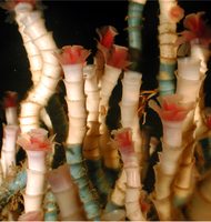
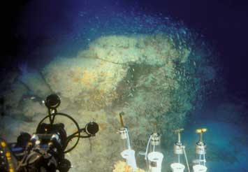
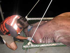
The deep seabed of the Gulf of Mexico
is home to cold communities of clams,
mussels and tube worms (shown above).
The ecology of the slope and shelf edge in the Florida Panhandle Bight is poorly known and woefully understudied (Schroeder and Woods, 2000) compared to the central and western Gulf (Rowe and Kennicutt II, 2009) where oil and gas extraction predominates. While it is clear that the Deepwater Horizon (DwH) oil spill and the use of dispersants in an effort to quell the spill can have profound effects on the living organisms in the water column, deep sea, slope, and shelf-edge, reverberating throughout the trophic system, the magnitude of this effect and its consequences for ecological processes remain ill-defined.
The objectives of Deep-C ecology researchers are to: (1) to define and quantify the diversity of biological responses to the dynamic physical and chemical properties of the environment, (2) to evaluate the impact of discharged and background hydrocarbons on community structure and function, and (3) to inform the development of both food web and earth system models.
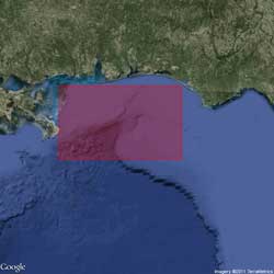
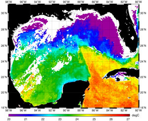
Studies are being conducted across trophic levels that include pelagic phytoplankton, pelagic and benthic microbial communities, meiofaunal, macrofaunal, and fish assemblages, from both organismal and ecological approaches. Six projects already underway provided sampling that extends from the shore to the deep sea (see figure below), collecting hydrographic, water chemistry, and biological data at all taxonomic levels. Results from this work document the influence of coastal and riverine waters offshore, the influence of deep sea waters on the shelf (caused by upwelling through the De Soto Canyon), and the presence of hypoxic areas at mid-shelf sites. These results also reveal trace levels of polycyclic aromatic hydrocarbons (PAHs) across the shelf, the source of which is currently unknown.
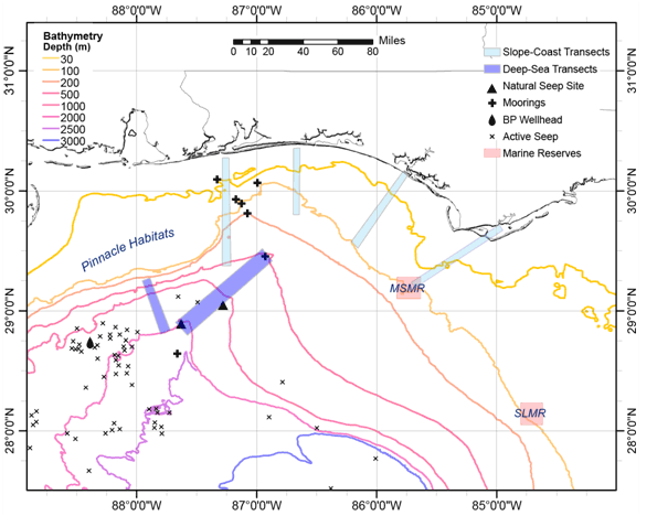
The study area for the "Deep Sea to Coast Connectivity in the Eastern Gulf of Mexico" Consortium encompasses the Florida Panhandle Bight. The rectangles represent proposed study areas: MSMR, Madison Swanson Marine Reserve; and SLMR, Steamboat Lumps Marine Reserve. Oil sources shown are the BP wellhead and the active natural seeps.
Both historical and newly-derived empirical data are being used to develop a food web model that links trophic interactions with hydrodynamic and biogeochemical data in order to define the drivers and spatial and temporal patterns of productivity. It is anticipated that the analyses of planktonic and benthic community responses over time will make significant contributions to our understanding of the severity and longevity of the oil spill, demonstrating the cumulative effect on mid- to upper-trophic level responses and resilience of the system.
Primary Productivity - Phytoplankton and microbes form the base of the trophic web, providing direct and indirect carbon transfer at the nexus of primary and microbial-loop production. Microbial plankton are typically limited by phytoplankton production, but allocthonous organic matter from terrestrial sources or the input of oil and dispersants can dramatically shift the balance of energy flow in the microbial loop and fundamentally change basic trophic interactions among lower trophic levels. Sedimentation of oil and detritus from the water columns provides an archival record of chemical constituency, environmental conditions, and biological effects of pre-spill, spill, and post-spill conditions (including evidence of recovery), which appear in progressively shallower core-depth intervals. Important primary producers in the Gulf of Mexico are photosynthesizing protists, including pelagic diatoms and nanoplankton. Their presence in sediments are particularly useful because they leave sedimentary records that extend from the present to far back in geologic time, enabling us to identify abrupt, large-scale changes in living populations and extreme environmental events. The nanoplankton response to the escalator effect of the De Soto Canyon is near-shore nanoplankton assemblages that mimic those of the open ocean, while the riverine influence causes riverine-like assemblages to become dominant on the shelf. The mixing of these water masses is an unknown, but provides a likely driver of production on the shelf, making the integration of physical and chemical tasks of the consortium with the biological characterizations key to understanding the productivity of the system and its resiliency to perturbation. Protists — phytoplankton, microzooplankton, and foraminifera — can be used as tracers to identify prevailing current flow year-round within the Deep-C study area. The objectives of this research, therefore, are (1) to quantitatively compare the historic (Pariente 1997) and current distributions of nanoplankton and microzooplankton within the photic zone of the study area and within the sediments in order to assess the relationship between the floras in the overlying water column and the sedimentary record; and (2) to determine the ecological responses of protists under varying environmental conditions (natural to anthropogenic events, including current Mississippi River flooding conditions).
Microbial Component - Deep-C ecology researchers are examining the effects of oil and settling algal blooms on critical biogeochemical processes catalyzed by sedimentary microorganism. Based on a combination of culture-based and cultivation-independent molecular approaches, researchers have observed that oil contamination from the DwH spill has a profound impact on the abundance and community composition of indigenous bacteria in Gulf sediments, and the evidence points to members of the Gammaproteobacteria (Alcanivorax, Marinobacter) and Alphaproteobacteria (Rhodobacteraceae) as key players in oil degradation there. The working hypothesis is that pulses of refractory (crude oil) and labile (phytoplankton cells) particulate organic matter change the permeabilities and biological mixing activities in the sediments across the shelf depth gradient and thereby the interfacial solute and particle transport that controls the sedimentary microbial community functions, degradation rates and redox zonation. It is hypothesized that parallel developments in microbial community response and biogeochemical reactions can be observed in sediments influenced by crude oil or/and phytoplankton particles but with distinct differences in the active species. Therefore, the team's research objectives are: (1) To quantify the spatial distribution and temporal changes of organic matter including petroleum hydrocarbons and algal material in sediments. (2) To determine the microbial community response to the deposition of refractory (petroleum hydrocarbons) and labile (plankton algae) organic matter sources as well as the synergistic effects caused by a combined deposition. (3) To quantify rates of benthic mineralization activity (oxygen consumption, dissolved inorganic and organic carbon production) and interfacial fluxes in sediments affected by oil and algae and relate them to parameters controlling transport of metabolites (permeability, macrofauna abundance).
Benthic Communities - Sediment-dwelling meiofauna (organisms ranging in size from 30 to 300μm, such as nematode worms and small crustaceans) and macrofauna (organisms > 300μm, such as polychaete worms and clams) that are short-lived and sensitive to pollution impacts make effective indicators of biologically-stressed systems (Hicks 1991). These organisms collectively provide important ecosystem services, including bioturbation – an engineering feat that modifies geochemical gradients and redistributes food resources from within sediments to the surface layers (Meysman et al. 2006). Any disruption of their activities can have a profound influence on trophic interactions. Indeed, benthic meiofauna and macrofauna form an integral component of the food web for benthic and demersal fish species, tying the benthic primary producers and bacterial communities to mid- and upper-trophic level organisms. Deep-C seeks to assess species abundance, richness, diversity, and community structure of meiofaunal and macrofaunal assemblages throughout the Florida Panhandle Bight. The primary question to be addressed in this research is, do these characteristics vary across depth strata, across seasons, and/or across topographic features? A second question of interest is, how does condition vary in response to natural hydrocarbon seeps?
Fisheries Species - Deep-C studies of the trophic interactions of fisheries species of the Florida Panhandle Bight are motivated by evidence that DwH oil reached the continental shelf from the deep sea via the De Soto Canyon, and by anecdotal evidence from fishermen and scientists that this event had a significant effect on fish health and community composition. Given the strong linkages between large-scale oceanographic features (e.g., the Loop Current), geomorphology (e.g., the De Soto Canyon, the Apalachicola River Delta), and fisheries productivity (Schroeder et al. 2000), the Deep-C Consortium has adopted an approach to evaluate post-spill impacts on the Gulf ecosystem that link results from the ecological research with those of the other Deep-C research areas. The goal is to survey fish assemblages to determine the level and effect of exposure to PAHs on fish health and characterize areas most likely affected by the spill. Deep-C ecology researchers seek to answer three general questions. (1) What are the spatial, temporal, and depth-mediated differences in the diversity, distribution, and abundance of fish assemblages in the deep sea, slope, and shelf edge of the region? (2) Are differences in exposure to PAHs correlated with any differences in fish health, based on age, size structure, and reproductive condition? (3) What are the physical and trophic linkages of this assemblage?
The Food Web Model - Data from Deep-C research will be integrated into a spatially-explicit three dimensional biogeochemical marine food web model, Atlantis, that contains sub-models for hydrographic processes, chemical and biological factors that influence primary productivity, food-web interactions among species, habitat availability, nutrient loading, biomagnification of pollutants, and other chemical and biophysical features crucial for ecosystem functioning, including climate effects. The model will be used to evaluate ecological, social, and economic questions relevant to the DwH oil spill and other extreme events that influence ecosystem health.
Sources:
Hicks, G. R. F.: 1991, 'Monitoring with Meiofauna: A Compelling Option for Evaluating Environmental Stress in Tidal Inlets', in: Coastal Engineering – Climate for Change, Auckland, New Zealand: 10th Australasian Conference on Coastal and Ocean Engineering, pp. 387391.
Meysman, F. J. R., J. J. Middelburg, and C. H. R. Heip. 2006. Bioturbation: a fresh look at Darwin's last idea. Trends in Ecology & Evolution 21:688-695.
Pariente, V. 1997. Coccolithophores of the Gulf of Mexico and their Relationship to Water-Column Properties. Ph. D. Dissertation. Texas A&M University, College Station.
Rowe, G. T. and M. C. Kennicutt II. 2009. Northern Gulf of Mexico continental slope habitats and benthic ecology study: Final report. OCS Study MMS 2009-039 U.S. Dept. of the Interior, Minerals Management. Service, Gulf of Mexico OCS Region.
Schroeder, W. W., C. F. Wood, and (eds). 2000. Physical/Biological Oceanographic Integration Workshop for the DeSoto Canyon and Adjacent Shelf October 19-21, 1999. OCS Study MMS 2000-074:168 pp. U. S. Department of the INterior, Minerals Management Service, Gulf of Mexico OCS Region, New Orleans, LA.
Schroeder, W. W. and C. F. Woods. 2000. Physical/Biological Oceanographic Integration Workshop for De Soto Canyon and Adjacent Shelf: October 19-21, 1999. OCS Study MMS 2000-074 U.S. Department of the Interior, Minerals Management Service, Gulf of Mexico OCS Region:168 pp.
Deep-C Research Areas
The Deep-C Consortium is a long-term, interdisciplinary study of deep sea to coast connectivity in the northeastern Gulf of Mexico. The study is investigating the environmental consequences of petroleum hydrocarbon release in the deep Gulf on living marine resources and ecosystem health. Deep-C will examine the geomorphologic, hydrologic, and biogeochemical settings that influence the distribution and fate of the oil and dispersants released during the 2010 Deepwater Horizon accident, and use the resulting data for model studies that support improved responses to possible future incidents.
The primary Deep-C research areas include:
This email address is being protected from spambots. You need JavaScript enabled to view it. for more information about Deep-C's research programs.
Deep-C was a four-year, interdisciplinary study of deep sea to coast connectivity in the northeastern Gulf of Mexico.Deep-C is no longer an active research project. The information on this website is for historical reference purposes only.
Home | About Us | Research Areas | Data Center | News & Multimedia | Education & Outreach
© Deep-C Consortium. All Rights Reserved.
This research was made possible by a grant fromThe Gulf of Mexico Research Initiative (GoMRI).
Copyright | Disclaimer | Privacy Policy