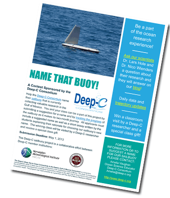
Name That Buoy!
|
|
And be a part of the research experience...
March 25, 2013 -- This month, the Deep-C Consortium launched a new vessel for scientific observations in the Gulf – an unmanned sailbuoy that will crisscross the northeastern Gulf of Mexico over the next two months. This self-powered, wind-propelled buoy is gathering information to help scientists understand how oil moved from the Macondo well (during the 2010 Deepwater Horizon oil spill) to the shorelines of states bordering the northeastern Gulf of Mexico, from Louisiana to Florida.
Currently, the new addition to Deep-C’s oceanographic research is simply referred to as “the sailbuoy.” While we watch and learn from the sailbuoy as it travels its planned course in the Gulf, Deep-C is also on the hunt for an appropriate name -- one that conveys the exciting nature of this research.
“We are following the sailbuoy's adventures as if it were a member of our scientific family. As it travels across the Gulf, it is sure to face adverse weather conditions and close encounters with other vessels.” says Dr. Eric Chassignet, Director of the Deep-C Consortium and the Florida State University Center for Oceanographic-Atmospheric Prediction Studies (COAPS). “We are therefore asking young scientists in the community – high school students across the Gulf states – to suggest a suitable name for our sailbuoy.”
All entries must include a suggested name as well as a short (250 words or less) essay written by the students explaining their rationale for choosing our sailbuoy’s new name. Suggested names can be up to three words or an acronym. The contest is open to high school classes only, and the class that submits the winning recommendation will be visited by a Deep-C researcher and receive a special class gift. See more about Deep-C’s “NAME THAT BUOY!” contest, which ends May 1, 2013.
Another important reason for Deep-C’s “NAME THAT BUOY!” contest is to raise awareness about the project so science educators and students will follow the sailbuoy’s journey and use it as a tool for learning more about ocean science and oil spill research, specifically in the Gulf of Mexico. ATTENTION TEACHERS: Check out NOAA's "Adopt-a-drifter" Lesson Plans page for lesson plans and activities related to ocean research that you can use in your classroom.
More about the sailbouy
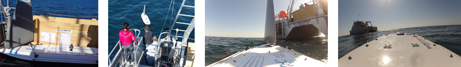
The sailbuoy is similar to a surfboard in shape and size. It is two meters in length and under prime wind conditions has an average speed of 1-2 knots (see the data sheet). It is equipped with two-way satellite communication for real-time data streaming and waypoint updates (the buoy is following a planned course but its navigation is monitored and can be modified remotely). This sailbuoy is part of a new generation of vehicles designed for marine observations that can keep station or travel from point to point, enabling scientists to expand and intensify the study of our seas and oceans. It is a technology developed by senior scientist Dr. David Peddie and his team at CMR Instrumentation in Bergen, Norway.
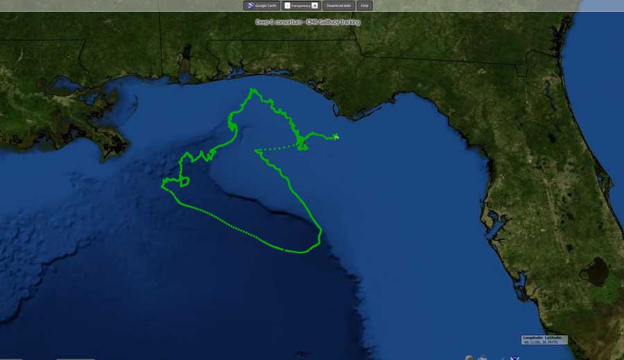 Deep-C’s sailbuoy is equipped with sensors for salinity, temperature, and oxygen and it is currently transmitting data to an Operations Center. The buoy’s two-month mission is to measure aspects of cross-shelf transport and upwelling events that occur near the head of the De Soto Canyon, a feature that looks like a huge gash in the continental shelf. As it moves, the sailbuoy will record and transmit real-time data on temperature, salinity, and oxygen fields to a satellite on an hourly basis. (Click on the tracking map to the left to see the buoy's latest location and to follow it online in near real-time.)
Another objective of the sailbuoy research is to investigate the "Mississippi River plume" – an enormous quantity of fresh sediment-rich rainwater runoff entering the Gulf of Mexico via the Mississippi River. This plume is visible, nutrient rich sediment that spreads out from the coastline, forming a kind of cloud in the water. Because the plume is one of the primary factors, along with wind and the Loop Current, that influences the distribution of the oil and other surface particles, it is crucial to have a clear understanding and representation of the Mississippi plume-De Soto Canyon interactions.
|
|
“A typical drifter buoy deployed around the De Soto Canyon would move out of the area within a few days,” explains Dr. Lars Hole, a senior scientist at the Norwegian Meteorological Institute and the Deep-C sailbuoy project leader. “What makes the sailbuoy extremely valuable to our research is that we can sustain observations for days, weeks, months or even longer from the same location. And we can navigate and change its location remotely from our Operations Center.”
Dr. Nico Wienders, a research faculty member in the Florida State University (FSU) Department of Earth Ocean and Atmospheric Science and a member of the Deep-C Consortium, led the expedition to deploy the buoy. “Launching the sailbuoy involved weeks of planning, organizing, testing, and rushing around. Not to mention a few unexpected bumps along the way,” Dr. Wienders recalled. “Our original March 4 launch had to be postponed due to weather conditions. Fortunately, the FSU Coastal and Marine Laboratory's RV Apalachee was available to execute the launch and a new date was set for March 15. We are now more than a week into our mission and the buoy is happily sailing towards her waypoints at the entrance of the De Soto Canyon.”
Check out the SailBuoy Blog ![]() for updates from the Deep-C scientists coordinating the project. Or visit our YouTube channel for a video about the sailbuoy launch on March 15.
for updates from the Deep-C scientists coordinating the project. Or visit our YouTube channel for a video about the sailbuoy launch on March 15.
The Deep-C consortium is a long-term, interdisciplinary study investigating the environmental consequences of petroleum hydrocarbon release in the deep Gulf of Mexico on living marine resources and ecosystem health. The consortium focuses on the geomorphologic, hydrologic, and biogeochemical settings that influence the distribution and fate of the oil and dispersants released during the Deepwater Horizon accident, and is using the resulting data for model studies that support improved responses to possible future incidents.
|
|

The Norwegian Meteorological Institute (Met.no) provides weather forecasts for Norway and Norwegian waters as well as more specialized services such as ice monitoring, oil spill and search and rescue forecast services. One of their core activities is the operation, data collection and the transmission of national and international observational data. They are a world leader in oil spill prediction. This email address is being protected from spambots. You need JavaScript enabled to view it. is a senior scientist in Met.no's Department of Operational Oceanography and Marine Meteorology. Dr. Hole specializes in applications of micro-meteorolological measurements, climate change effects, atmospheric transport and deposition of pollutants to vegetation and snow, trend analysis, snow characterization, sound propagation in the atmosphere, marine meteorology and oil drift modeling. He is currently focusing on wind and wave energy research and extreme ocean wave forecasting.

This email address is being protected from spambots. You need JavaScript enabled to view it. is a research faculty at Florida State University and holds a PhD in physical oceanography from France in 2000. Dr. Wienders spends half of his time in the field, preparing instruments and collecting data. He recently went several times to Antarctica for the DIMES project. Within Deep-C, Dr. Wienders dedicates much of his time to set up and analyze experiments that use moorings, floats and, most recently, the sailbuoy. Time on land is spent working with supercomputers and very high resolution model simulations. Some current projects focus on the topographic control of the Gulf stream, the potential vorticity budget in the North Atlantic or, for instance, within the CARTHE project (another GoMRI consortium) on the non-hydrostatic and multiphase modeling of the nearfield oil and gas plume observed during the Deepwater Horizon spill.
For details about the NAME THAT BOUY! contest or educator tools associated with the sailbuoy project, This email address is being protected from spambots. You need JavaScript enabled to view it., Deep-C Ocean Science Educator.
Deep-C was a four-year, interdisciplinary study of deep sea to coast connectivity in the northeastern Gulf of Mexico.Deep-C is no longer an active research project. The information on this website is for historical reference purposes only.
Home | About Us | Research Areas | Data Center | News & Multimedia | Education & Outreach
© Deep-C Consortium. All Rights Reserved.
This research was made possible by a grant fromThe Gulf of Mexico Research Initiative (GoMRI).
Copyright | Disclaimer | Privacy Policy