New Research Illustrates Mississippi River’s Role in Transport of Oil and Pollutants in Gulf of Mexico
Study establishes first-ever connections between the Mississippi River plume and transport of oil released by the 2010 Deepwater Horizon oil spill
|
Example of model simulation of strong influence of Mississippi fronts (left, black line) on the observed Surface Oil Patch (SOP, right). Incident when the Mississippi waters (blue and purple colors) entrained oil toward the coasts west of the Mississippi Delta. The Macondo well location is marked with an X.
|

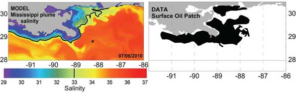
MIAMI (October 23, 2013) – A new study led by scientists at the University of Miami (UM) Rosenstiel School of Marine and Atmospheric Science showed that the complex circulation from the Mississippi River plume played a substantial role in the transport and fate of the oil following the 2010 Deepwater Horizon incident. These findings provide new information on the transport of oil and other pollutants in the Gulf of Mexico. UM Research Associate Professor Villy Kourafalou developed a high-resolution model to examine the movement of the surface oil patch resulting from the deep oil release from the Deepwater Horizon under the influence of daily variability of the Mississippi River. The study employed NOAA observations for the evolution of the surface oil patch and revealed that fronts created by the Mississippi plume helped to keep oil released during the Deepwater Horizon incident away from the coasts east of the Mississippi Delta, while plume currents captured some oil to the west of the Mississippi Delta.
“Since the Gulf of Mexico is such a complex ocean system, and the oil spill was near the Mississippi Delta, we realized we had to carefully account for both the offshore currents and the coastal currents, which are largely dominated by the Mississippi River plume,” said Kourafalou. “The model was validated with data and is now part of an Earth System modeling framework to help inform decision makers in the future.”
During the response to the Deepwater Horizon incident, emergency managers wondered if flooding the Mississippi River might help to divert the oil being released into the water from impacting communities on the Gulf’s north coast. However, no operational computer models with details in river plume dynamics existed that might help predict how the environment might react to being flooded.
This study marks the first time a connection is established between the near surface signatures of a large river plume and the hydrocarbons released from a deep oil plume. The new prediction modeling system can help better understand the transport of oil and other pollutants under the complex circulation in the Gulf of Mexico. Waters of Mississippi origin can be often traced as far south as the Florida Straits, potentially impacting the Florida Keys.
The research, published in the Oct. 2013 issue of the Journal of Geophysical Research: Oceans, was funded by grants from the Gulf of Mexico Research Initiative and the National Science Foundation.
|
|

Dr. Villy Kourafalou is a member of the Deep-C (Deep Sea to Coast Connectivity in the Eastern Gulf of Mexico) Consortium, which is investigating the environmental consequences of petroleum hydrocarbon release in the deep Gulf on living marine resources and ecosystem health. Deep-C is examining the geomorphologic, hydrologic, and biogeochemical settings that influence the distribution and fate of the oil and dispersants released during the Deepwater Horizon (DwH) accident, and using the resulting data for model studies that support improved responses to possible future incidents.
The University of Miami is the largest private research institution in the southeastern United States. The University’s mission is to provide quality education, attract and retain outstanding students, support the faculty and their research, and build an endowment for University initiatives. Founded in the 1940’s, the Rosenstiel School of Marine & Atmospheric Science has grown into one of the world’s premier marine and atmospheric research institutions. Offering dynamic interdisciplinary academics, the Rosenstiel School is dedicated to helping communities to better understand the planet, participating in the establishment of environmental policies, and aiding in the improvement of society and quality of life.
The Gulf of Mexico Research Initiative is an independent body established by BP to administer the company's 10-year, $500 million commitment to independent research into the effects of the Deepwater Horizon incident. Through a series of competitive grant programs, the GRI is investigating the impacts of the oil, dispersed oil, and dispersant on the ecosystems of the Gulf of Mexico and the affected coastal States in a broad context of improving fundamental understanding of the dynamics of such events and their environmental stresses and public health implications.
The Deep-C Consortium is a long-term, interdisciplinary study investigating the environmental consequences of petroleum hydrocarbon release in the deep Gulf of Mexico on living marine resources and ecosystem health. The consortium focuses on the geomorphologic, hydrologic, and biogeochemical settings that influence the distribution and fate of the oil and dispersants released during the Deepwater Horizon accident, and is using the resulting data for model studies that support improved responses to possible future incidents.
Deep-C was a four-year, interdisciplinary study of deep sea to coast connectivity in the northeastern Gulf of Mexico.Deep-C is no longer an active research project. The information on this website is for historical reference purposes only.
Home | About Us | Research Areas | Data Center | News & Multimedia | Education & Outreach
© Deep-C Consortium. All Rights Reserved.
This research was made possible by a grant fromThe Gulf of Mexico Research Initiative (GoMRI).
Copyright | Disclaimer | Privacy Policy