Student team working on experimental radar unit
Project by FAMU/FSU engineering seniors to enhance oil spill detection
|
|
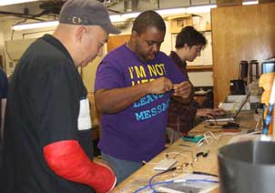
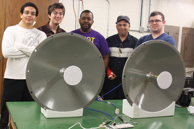 Members of the Radar Team (pictured left to right): Juan Alvare Z.,
 TALLAHASSEE, FL (Posted April 2, 2013) – Early and accurate detection of an oil slick can help locate the source and contain the extent of its damage. A team of students from the Florida A&M University (FAMU)/Florida State University (FSU) College of Engineering is working to enhance oil spill detection methods by characterizing the physical properties of different oil-water emulsion ratios on a radar signal. This is crucial for accurate interpretation of radar imagery from satellites when they are being used to detect oil spills.
"This team of engineering seniors is fabricating an experimental radar unit that will be used to measure oil thickness under laboratory conditions," explains Dr. Ian MacDonald, Professor of Oceanography in the Department of Earth, Ocean and Atmospheric Science at FSU and an advisor to the group. "This will help to calibrate satellite measurements and could lead to the development of field instruments."
The project involves the design and implementation of a laboratory scale directional radar system that can effectively determine the density of oil at various incident angles for use in the calibration of Synthetic Aperture Radar (SAR). SAR is often used to determine oil spill boundaries on water. The potential of SAR to enhance detection of oil emulsions is a pioneer mission that this team has undertaken.
During the Deepwater Horizon oil spill, intense efforts were made to mitigate and control thick patches of oil drifting freely on the ocean. Some of the coordinated response operations included skimming, burning, and application of dispersants over thick oil.
"The project has the potential to significantly improve coordinated response operations during an oil spill. If we are able to validate our lab measurments with the satellite data, we will be able to provide valuable information to the U.S. Coast Guard and NOAA during a crisis, allowing them to coordinate these contingency operations more effectively," explains Dr. Oscar Garcia-Pineda, a geophysicist at FSU has been an advisor and works closely with the group.
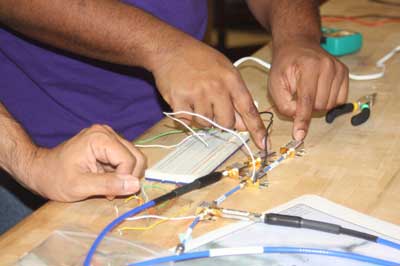
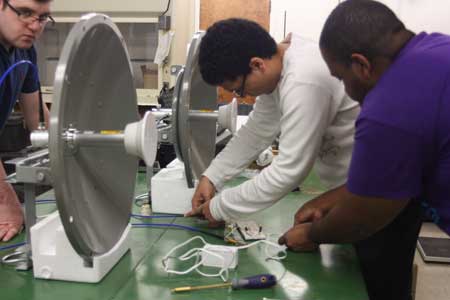
The system designed by the student team is comprised of a pair of receiver and transmitter antennas, a C-band frequency signal generator circuit, a digital signal processer built on field programmable gate array (FPGA) technology, and a database server. The 3-foot (0.9144m) parabolic antennas are highly directional with a large frontal transmission lobe. The wave tank being used in the testing is approximately 2 feet wide so a transmitter with C-Band frequency (~5.4 Gigahertz) capabilities was selected to allow for adequate radar beam width coverage. All active devices are powered by a 5 to 6 volt source in the transmitter.
|
|
|
|
|
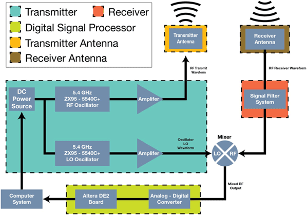
General overview of the system block diagram. |
The method of determining the amount of oil in the tank comes from measuring the signal received back from the tank when a known amount of oil has been added. After calibration of the various signal levels, unknown levels of oil can be determined. Various conditions will affect how powerful the signal received will be, such as wave and wind motion. All of these aspects will factor into the best conditions for measuring.
The engineering team hopes that this project will set the ground work for other advanced applications and radar experiments for the Department of Earth, Ocean, and Atmospheric Science (EOAS) at FSU.
(Photo credit: Diana Villa)
Additional Specifications: To handle the signal processing side of the system, an Altera DE2 FPGA board was selected in order for easy connectivity with an Analog to Digital Converter (ADC) and to a computer system. A high speed ADC about around 150 megasamples will be used to read in the mixed signal from the receiver and convert it to a digital value. A web database done in a PHP scripting language can be accessed by a computer system that takes data off the DSP system and performs time averaging of the received power signal for the purpose of quantifying the amount of oil in the tank. The computer system can be any device that can access the system’s online server. This feature allows for easy access for many users at the same time.
Dr. Ian MacDonald is a professor at the Florida State University. He is an oceanographer of deep-ocean extreme communities. The physical settings include natural hydrocarbon seeps, gas hydrates, and mud volcano systems. In his project work, he uses satellite remote sensing to locate natural oil releases on the ocean surface. Specialty cameras provide high resolution and time-series imaging of seep fauna and processes at the ocean floor. GIS techniques are used for assessing biological communities and geologic features with submersibles and towed cameras.
Dr. Oscar Garcia-Pineda is a geophysicist and a Scientist at Florida State University. His main research has focused on the development of semi-automated image processing algorithms to map coastal and oceanographic processes. As a geoscientist, he has been working to integrate satellite remote sensing data with geophysical data for exploration of hydrocarbons and energy resources in the deep marine environment. He participates with NOAA as a member of the Sea Surface Roughness Science Team applying Synthetic Aperture Radar (SAR) imagery to derive floating oil properties.
The Deep-C consortium is a long-term, interdisciplinary study investigating the environmental consequences of petroleum hydrocarbon release in the deep Gulf of Mexico on living marine resources and ecosystem health. The consortium focuses on the geomorphologic, hydrologic, and biogeochemical settings that influence the distribution and fate of the oil and dispersants released during the Deepwater Horizon accident, and is using the resulting data for model studies that support improved responses to possible future incidents.
Deep-C was a four-year, interdisciplinary study of deep sea to coast connectivity in the northeastern Gulf of Mexico.Deep-C is no longer an active research project. The information on this website is for historical reference purposes only.
Home | About Us | Research Areas | Data Center | News & Multimedia | Education & Outreach
© Deep-C Consortium. All Rights Reserved.
This research was made possible by a grant fromThe Gulf of Mexico Research Initiative (GoMRI).
Copyright | Disclaimer | Privacy Policy