The Deep-C SailBuoy Project
New Marine Device Used for Scientific Observations in the Gulf of Mexico
| Share | Tweet |
|
|
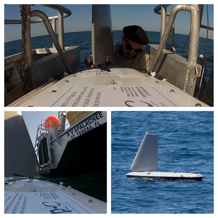
The Deep-C SailBuoy is an unmanned sailing vessel deployed by Deep-C scientists in the northeastern Gulf of Mexico (read about the launch). It is self-powered, wind-propelled, and it navigates the oceans autonomously.
The SailBuoy is similar to a surfboard in shape and size — two meters in length and under prime wind conditions has an average speed of 1-2 knots (Download a data sheet). It was equipped with two-way satellite communication for real-time data streaming and waypoint updates. While at sea during Summer 2013, it transmitted data to the Deep-C Operations Center at regular intervals along a planned course (see our cruise map below).
The Deep-C Sailbuoy is part of a new generation of vehicles designed for marine observations that are enabling scientists to expand and intensify the study of our seas and oceans. It can keep station or travel from point to point, and is a technology owned by the Norwegian company CMR.
The SailBuoy's Mission and What We Will Learn
The mission of Deep-C's SailBuoy is to gather scientific data throughout the northeastern Gulf of Mexico. A number of sensors have been mounted on the SailBuoy, allowing us to monitor seawater parameters, such as temperature, salinity and dissolved oxygen.
Collection and analysis of this data will help Deep-C scientists better understand how particles and dissolved substances (such as oil) are transported from the deep Gulf to the shelf waters in the northeastern Gulf across the continental shelf and the DeSoto Canyon -- an erosional valley that cuts through the continental shelf in the northern part of the Gulf. Another objective of Deep-C's SailBuoy project is to investigate and better understand the "Mississippi River plume" -- a plume caused by fresh sediment-rich rainwater runnoff entering the Gulf of Mexico via the Mississippi River. This plume is visible, nutrient rich sediment that spreads out from the coastline, forming a kind of cloud in the water.
Follow the Deep-C SailBuoy
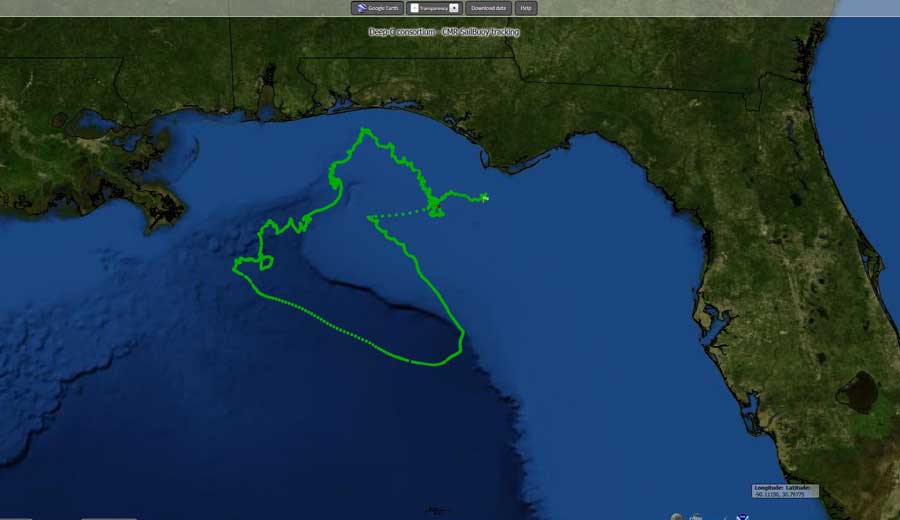
Deep-C's SailBuoy was launched on March 15, 2013 approximately 11 nautical miles (nm) south of Cape San Blas. She was at sea for approximately two months, and during its mission it sailed approximately 840nm on a cruise track across the Gulf coast, from the Florida Panhandle to West Louisiana. Check out the SailBuoy Blog ![]() for an account of its journey from the Deep-C scientists coordinating the project. Click on the map below to see the buoy's cruise track.
for an account of its journey from the Deep-C scientists coordinating the project. Click on the map below to see the buoy's cruise track.
More about Deep-C and the SailBuoy Project
|
|
The SailBuoy project is a collaborative effort between researchers at The Florida State University and the Norwegian Meteorological Institute -- both members of the Deep-C Consortium. Deep-C is a long-term, interdisciplinary study investigating the environmental consequences of petroleum hydrocarbon release in the deep Gulf of Mexico on living marine resources and ecosystem health. The Consortium focuses on the geomorphologic, hydrologic, and biogeochemical settings that influence the distribution and fate of the oil and dispersants released during the Deepwater Horizon accident, and is using the resulting data for model studies that support improved responses to possible future incidents.
The SailBuoy project is part of Deep-C's physical oceanography research which seeks to, among other things, understand how particles and dissolved substances (such as oil) travel from the deep sea to the Louisiana, Mississippi, Alabama and Florida shorelines. This involves cross-shelf transport and upwelling mechanisms, which the SailBuoy is capable of measuring. For example, researchers will be able to monitor the occurrence of upwellings (an upward flow of deep-sea water) via recorded and transmitted temperature, salinity and oxygen fields, allowing them to better understand the conditions that lead to these events. Another important objective of the SailBuoy project is to investigate and describe the Mississippi river plume distribution. Deep-C partners from the University of Miami Rosenstiel School of Marine Science are currently forecasting the location of the plume in a model configuration, and data from the SailBuoy project will help them improve their models by sampling in the plume area for about a month. Since it has been demonstrated that the location of the Mississippi River plume influences the distribution of particles and and dissolved substances in the water, at least at the surface level, it is crucial to have a proper understanding and representation of this, and the results from the buoy experiment will contribute to our understanding. Sea surface salinity measurement via satellite do not provide, at the moment, sufficient resolution and accuracy and instead, the SailBuoy experiment will produce a very unique dataset.
The SailBuoy Project leader is Dr. Lars R. Hole of Met.no in close collaboration with Dr. Nico Wienders of FSU. The Sailbuoy was developed by CMR Instrumentation, in Bergen, Norway by senior scientist David Peddie and his group. More information can be found at www.sailbuoy.no.
|
|

The Norwegian Meteorological Institute (Met.no) provides weather forecasts for Norway and Norwegian waters as well as more specialized services such as ice monitoring, oil spill and search and rescue forecast services. One of their core activities is the operation, data collection and the transmission of national and international observational data. They are a world leader in oil spill prediction. This email address is being protected from spambots. You need JavaScript enabled to view it. is a senior scientist in Met.no's Department of Operational Oceanography and Marine Meteorology. Dr. Hole specializes in applications of micro-meteorolological measurements, climate change effects, atmospheric transport and deposition of pollutants to vegetation and snow, trend analysis, snow characterization, sound propagation in the atmosphere, marine meteorology and oil drift modeling. He is currently focusing on wind and wave energy research and extreme ocean wave forecasting.

This email address is being protected from spambots. You need JavaScript enabled to view it. is a research faculty at Florida State University and holds a PhD in physical oceanography from France in 2000. Dr. Wienders spends half of his time in the field, preparing instruments and collecting data. He recently went several times to Antarctica for the DIMES project. Within Deep-C, Dr. Wienders dedicates his time to the mooring, SailBuoy, and float experiments. Time on land is spent working with supercomputers and very high resolution model simulations. Some current projects focus on the topographic control of the Gulf stream, the potential vorticity budget in the North Atlantic or, for instance, within the CARTHE project (an other GoMRI consortium) on the non-hydrostatic and multiphase modeling of the nearfield oil and gas plume observed during the Deepwater Horizon spill.
Deep-C was a four-year, interdisciplinary study of deep sea to coast connectivity in the northeastern Gulf of Mexico.Deep-C is no longer an active research project. The information on this website is for historical reference purposes only.
Home | About Us | Research Areas | Data Center | News & Multimedia | Education & Outreach
© Deep-C Consortium. All Rights Reserved.
This research was made possible by a grant fromThe Gulf of Mexico Research Initiative (GoMRI).
Copyright | Disclaimer | Privacy Policy